Waikuku
Farming locality 16 km south of Amberley and 33 km from Christchurch, with a 2013 population of 903. An increase from 540 people in 1991 indicates the town’s popularity with Christchurch commuters. A rope and twine works, which initially used flax from local swamps, closed in 1987. Waikuku Beach is a small coastal settlement on Pegasus Bay.
Woodend
Town 6.5 km north-east of Kaiapoi. Between 1996 and 2006 its population surged by 67%, and by 2013 had increased further to 2,679, largely because it is within commuting distance of Christchurch. It is in an area of mixed farming, market gardening and fruit-growing.
Tuahiwi
Settlement between Woodend and Rangiora, 6 km north of Kaiapoi. Land was reserved there for Māori in the 19th century, and Tuahiwi has remained the main settlement of the Ngāi Tūahuriri hapū (sub-tribe) of Ngāi Tahu. A Māori mission was established at Tuahiwi in the 19th century, and a historic church (1867) is one of the settlement’s notable buildings. Te Wai Pounamu College, a school for Māori girls which later moved into Christchurch, was founded at Tuahiwi in 1909.
Pegasus Bay
The broad sweep of coastline north of Banks Peninsula takes its name from the vessel Pegasus, which surveyed this part of the South Island coast in 1809. Seaside suburbs of Christchurch lie on the southern end of the bay. Further north, holiday settlements, some with campgrounds, lie behind dunes. The beach is sandy, unlike the shingle beaches of the Canterbury Bight south of Banks Peninsula.
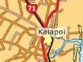
Kaiapoi
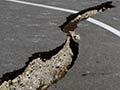
One of the principal towns of North Canterbury, 19 km north of Christchurch. It had a population in 2013 of 5,860, a drop of 21% since 2006. Another 2,000 live mainly on lifestyle blocks in surrounding country districts. The decrease in population was a result of the severe damage suffered by Kaiapoi in the September 2010 Darfield earthquake and again in the February 2011 Christchurch earthquake. The effect was especially severe in east Kaiapoi and along the river, where almost 1,000 homes were located in the ‘red zone’ and had to be demolished. Some important heritage buildings such as the museum (formerly the courthouse), the Methodist parsonage and the community centre were also lost.
The site of the large Ngāi Tahu pa, Kaiapoi, is 11 km north of the town. Built in the 1700s, it was besieged and sacked in 1831–32 by the forces of Ngāti Toa leader Te Rauparaha.
The town developed in the 1850s on Kaiapoi Island, between the south and north branches of the Waimakariri River. Subsequent river works have channelled the river south of the town.
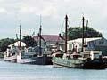
Kaiapoi was a busy port in the 1860s. After the railway reached Kaiapoi in 1872, the port remained in intermittent use until 1967. A small coastal trading vessel, the Tuhoe, now offers trips on the river.
Local industries have included freezing works, woollen mills, sawmills, factories for furniture, electrical appliances, clothing and shoes, and general engineering and quarrying.
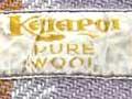
Warmth in wartime
Established in the 1870s, the Kaiapoi Woollen Manufacturing Company was a major local employer for over a century, producing goods with a national reputation for quality. The mill boomed especially in times of war, making woollen uniforms for soldiers fighting in the South African War, the first and second world wars, and the Korean War.
Waimakariri River
161-km river that flows into the sea just north of Christchurch. Renamed the Courtenay by the Canterbury Association settlers, it soon reverted to its Māori name, poetically translated as ‘wintry cold water’. The most northerly glaciers in the Southern Alps feed its headwaters, in Arthur’s Pass National Park. It flows through a wide upper valley with spectacular glaciated landforms, then threads through a deep gorge. The lower reaches of the gorge are seen by travellers on the train to Arthur’s Pass.