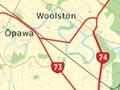


Woolston
South-eastern suburb of Christchurch. Industries like wool scouring, which needed plentiful water, grew along the Heathcote River, and Woolston became a centre of industry. Its position on the railway line to Lyttelton increased its industrial importance.
In the 20th century Woolston became the centre of New Zealand’s rubber industry. There were also a shoe polish factory, and a gelatine and glue works. Factory workers living nearby gave Woolston a strong working-class identity. It was a self-governing borough until 1921.
Brass and rubber
In May 1883 the Woolston Brass Band was formed, continuing the English working-class tradition of band music. It is now the Skellerup Woolston Brass Band, named after its major sponsor, rubber manufacturing firm Skellerup Industries Ltd. The band has a national reputation and has won numerous championships.
Heathcote River
River flowing through several of the city’s southern suburbs. The springs which feed it are south-west of Christchurch. Industries became established along the lower Heathcote River from the 1850s, especially in Woolston and Radley. Several wharves on its banks were used by small ships which crossed the Sumner Bar into the estuary.
The river was badly polluted until the Woolston industrial sewer was built in 1966. Flooding was also severe, but from 1986 the Woolston Cut allowed floodwaters to bypass a long loop of the river. The Canterbury earthquakes increased the danger of flooding.
Ōpawa
The most fashionable of Christchurch’s southern suburbs, along with neighbouring St Martins. Where Ōpawa Road crosses the Heathcote River was the site of a kāinga (small settlement) in Māori times, known as Ōpawaho. The same name was used for the Heathcote River. Much of St Martins, and Beckenham to its west, remained farmland until well into the 20th century. There were no areas red-zoned after the earthquakes, but the supermarket and other businesses were irreparably damaged.
Sydenham
Central suburb north-west of Ōpawa. Sydenham was a self-governing borough from 1877 until 1903. Its working-class residents were employed at factories along the railway line that separates Sydenham from central Christchurch. From the 1950s on, most of the cottages and small houses disappeared as the commercial and light-industrial zone spread south.
The suburb was known for political radicalism in the 19th century, and was a centre of the prohibition and women’s suffrage movements.
In the 20th century, the Sydenham electorate was staunchly Labour. One of the members who represented Sydenham in Parliament, Mabel Howard, was the country’s first woman cabinet minister. Many historic commercial buildings, especially along Colombo Street, were lost in the February 2011 earthquake.
Spreydon
One of the larger southern suburbs, Spreydon had its own borough council between 1911 and 1921. Lacking major institutions or facilities, it has had a low-key identity. However, Pioneer Stadium, a leisure centre, opened in 1978. The many streets lined with inter-war bungalows give it architectural interest.
Addington
Inner industrial suburb west of Sydenham. It grew around the Addington railway station, which opened in the 1860s. Factories and warehouses spread along the railway line. The railway workshops were Christchurch’s largest industry for many years. Christchurch’s new railway station opened on part of the former workshops land in 1993.
Also bearing the Addington name were the stock saleyards, show grounds and trotting race course. Addington flourished after the earthquakes. With the inner city cordoned off or damaged, cafés, bars, restaurants and cultural institutions such as the Court Theatre sprang up or moved there. Rugby League Park was rebuilt to become the Christchurch Stadium and the city’s major rugby venue following the abandonment of Jade Stadium.
Halswell
One of the fastest growing suburbs, at the city’s south-western boundary. Halswell was a separate village on the highway to Akaroa on Banks Peninsula until tracts of the former green belt were subdivided. It is now almost joined to the city by housing.