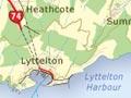
The Port Hills
Hills between Christchurch and Lyttelton Harbour. They are the eroded remnants of the northern rim of the Lyttelton volcano, and run from Godley Head at the entrance to Lyttelton Harbour round to Gebbies Pass at the harbour’s head.
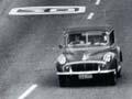
The 1867 Lyttelton rail tunnel cut through the hills, which were a major barrier between city and port. The older Bridle Path crosses the hills between Lyttelton and Heathcote. The road over Evans Pass from Sumner to Lyttelton was completed in 1857, and carried all traffic between the city and its port until the road tunnel was opened in 1964.
The Summit Road, which followed the crest of the Port Hills from Evans Pass to Gebbies Pass, was built during the 1930s on the initiative of H. G. Ell. Along its route are quaint rest houses: The Sign of the Takahe, The Sign of the Bellbird and The Sign of the Kiwi. Large areas of the hills are publicly owned, but sheep farming continues.
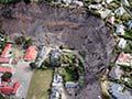
The epicentre of the February 2011 earthquake was at the Port Hills, so the area suffered substantial damage. Over 700 properties were eventually red-zoned for demolition or removal. The Summit Road was affected by huge rock falls, and the section from Rāpaki to the Bridle Path was opened to cyclists and walkers only in 2014, with the route further east closed to all.
In the footsteps of pioneers
When the Canterbury Association settlers arrived at Lyttelton in 1850, the road to Christchurch via Sumner had not been completed. They had to carry their worldly goods up the steep bridle track, which led over the saddle to the Heathcote Valley. It is now a well-used public walkway, with memorials and seats to mark its significance.
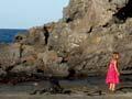
Sumner
Seaside suburb at the eastern end of the Port Hills. There was a village there from the earliest years of European settlement, and it was an independent borough until 1945. Until the road tunnel of 1964, the main road between Christchurch and Lyttelton passed through Sumner.
Linked by tram to the city from 1888, Sumner became a popular resort for city folk. Cave Rock, an unusual volcanic lava deposit on the foreshore, has delighted many generations of Christchurch children. Car access became easier after 1937, when a road alongside the tram causeway across McCormacks Bay was opened.
Most of Sumner occupies the flat floor of a valley, but from the early 1900s houses were also built on Clifton Hill and Scarborough Head. By the 2000s the appeal of living near the sea boosted the number of apartments, cafés, bars and restaurants. The earthquakes hit the area hard – properties on the hill, especially Clifton, suffered from landslips, while houses below, close to the cliffs, were in danger from rock falls and cliff collapses.
Redcliffs
Suburb on the southern shore of the Avon–Heathcote estuary. The area grew as a residential suburb from the early 1900s. One of the oldest archaeological sites in Canterbury, from the moa-hunter period of Māori culture, is centred on a cave and flat ground at Redcliffs. There were deaths from rock falls in the February 2011 earthquake.
Heathcote
Suburb lying in a valley on the western side of the Port Hills. At the foot of the Bridle Path and at the northern portals of the rail tunnel of 1867 and road tunnel of 1964, Heathcote became an industrial centre, with early brickworks and maltworks. Along with the neighbouring ‘sun-trap’ valleys of Horotane and Avoca, the valley supported orchards. Heathcote was exposed to serious falls of boulders and rocks in the 2011 earthquake.
Ferrymead
Location near where the Heathcote River enters the Estuary. After the first European settlers had climbed over the Bridle Path, they had to cross the Heathcote River on their way to the site of Christchurch.
The ferry from which Ferrymead takes its name began operating in 1850. Prior to the Lyttelton rail tunnel, goods were shipped to wharves on the lower Heathcote River. The railway from Christchurch to the wharf at Ferrymead opened in 1863. This was the first public steam railway in New Zealand. Ferrymead Historic Park, a major museum of transport and technology, has been developed since the 1960s. Ferrymead lost a supermarket and shops in the 2011 earthquake.
Cashmere Hills
The oldest suburb on the lower flanks of the Port Hills. The first houses were built in the 1890s. It flourished after trams reached The Sign of the Takahe rest house. Cashmere became fashionable, with a slightly bohemian reputation. The name came from the Kashmir estate owned by early settler John Cracroft Wilson, who was born in India.
Other hill suburbs which grew later include Westmorland to the west, and Huntsbury Hill, Hillsborough and Murray Aynsley Hill to the east. Further east, Mt Pleasant and St Andrew’s Hill overlook the Estuary. Most houses in the area suffered some damage in the February 2011 earthquake.