
He kōrero whakarapopoto
Early towns
New Zealand’s first towns and cities were carefully planned. New Zealand Company settlements such as Wellington, New Plymouth and Nelson were envisaged as towns serving a rural society, where landowners ruled the working class – this was not how the towns actually developed.
It took time for farms to be established, and towns were slow to grow. Workers quickly acquired land.
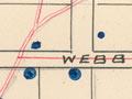
Town plans were based on grids, regardless of the landscape. This meant some streets were very steep – Dunedin has the steepest street in the world.
Free-market ideas became fashionable, and people thought towns should be left to developers rather than being planned. Houses could be next to dangerous factories and rubbish was thrown anywhere. Water became polluted. The death rate from diseases like typhoid rose.
Town planning
From the mid-1870s people realised that towns needed plans for sewerage and clean water, and land should be zoned for houses or factories.
In the early 20th century planning copied English ideas of garden cities – houses set in park-like settings and streets that curved through the lanscape. In New Zealand these ideas were adapted to garden suburbs. Durie Hill in Whanganui was one example, built in the 1920s.
In 1926 the Town Planning Act was passed. It required councils to prepare town plans. Later the government also required rural development to be planned.
Suburbs
State housing areas were developed as garden suburbs. There were large reserves, and houses had big sections. Suburbs grew and expanded out into farm land. Planners tried to find ways to limit this. Some cities planned a belt of farm land which could not be subdivided.
Some suburbs became cities in their own right. Manukau became a city in 1965. At first it was separate from Auckland, but over time suburbs filled in the gap.
Porirua was planned as a satellite city to Wellington and had a distinct garden-city design.
Motorways
As cities sprawled and traffic increased, planners suggested building motorways. In Auckland and Wellington motorways were ploughed through inner-city suburbs despite people’s protests.
Urban changes
The charms of older houses began to be appreciated, and many inner-city houses were restored.
The government decided not to regulate city plans any more in the 1970s. Instead people could take any complaints to a tribunal. In 1991 the Resource Management Act was passed. People could build what they liked as long as it did not damage the environment.
By the late 20th century fewer regulations meant cities began to change, with more apartments and a café culture. Other changes were less welcome: a property-building boom saw many ornate old buildings torn down and replaced by skyscrapers. Cities were ringed with malls and business parks.
People began to buy lifestyle blocks on land near the city.
Urban design
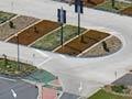
Councils began to focus on urban design which did no harm to the environment and valued the city’s heritage.