
Waihau Bay
Settlement 42 km from Gisborne, known also as Loisels Beach, which has grown since 1990 from a single homestead into a small community due to subdivision of the property into small lifestyle blocks.
The bay is 6 km from the main road and is popular in summer for its ‘freedom camping’ area administered by the Gisborne District Council. The old coach route followed the beach to its northern end before climbing up over the hills and down to Tolaga Bay.
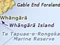
Whāngārā
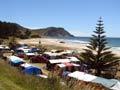
Locality 30 km from Gisborne via State Highway 35. Nestled between rolling hills and the Pacific Ocean, Whāngārā-mai-i-Tawhiti (Whāngārā from afar) is the home of the ancestor Paikea and several others responsible for many of the modern-day hapū groupings spread throughout the East Coast. The hapū which resides at Whāngārā is Ngāti Konohi.
Local tradition recounts that Paikea arrived in Aotearoa from Hawaiki on the back of a whale. Whāngārā gained global fame in 2004 thanks to the film Whalerider, adapted from the book of the same name by Witi Ihimaera, which drew on the Paikea story. Its lead actor, Keisha Castle-Hughes, was nominated for an Oscar. According to tradition, the whale turned into stone, and is now the island of Whāngārā, immediately offshore.
Te Tapuwae o Rongokako Marine Reserve
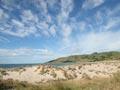
Te Tapuwae o Rongokako (the footprint of Rongokako) reserve is 2 km south of Whāngārā. The 2,450-hectare reserve was established in 1999, the product of a partnership between the Department of Conservation and Ngāti Konohi. It takes in the coastal waters between Whāngārā and Pouawa, and includes a variety of habitats characteristic of the coastal waters between East Cape and Māhia.
Pouawa
Locality 15 km north of Gisborne on State Highway 35 at the point at which it leaves the coastline and heads overland towards Tolaga Bay. A bridge over the Pouawa River marks the location. In the days of horse-drawn coaches there was a hotel and school.
On 26 March 1947 a tsunami caused a surge about 8 metres above normal sea level, sweeping the 36-year-old wooden bridge half a mile upstream.
Dunelands at Pouawa are protected but can be visited.
Tatapouri
Locality 13 km from Gisborne on State Highway 35, at the base of Tatapouri Point. It has a holiday park, and features crayfish and deep-sea fishing. Its hotel was damaged in the 1947 tsunami and destroyed by fire in 1996. At Makorori beach, just before Tatapouri, houses cluster under the point’s south-facing escarpment.
Wainui
Wainui, 6 km from Gisborne, has one of New Zealand’s great surfing beaches. Facing out into the South Pacific Ocean, the beach sees more substantial waves than Poverty Bay. Nearby Tuaheni Point marks the entrance to the bay. With Okitu, Wainui forms a 3-kilometre-long beach settlement.
Kaiti
Suburban area of Gisborne on the eastern side of the Tūranganui River, opposite the central business district. In the neighbourhoods of Outer Kaiti, Kaiti and Tamarau nearly three-quarters of the population identified as Māori in 2013, compared with around half in the city as a whole.
A famous rock
Te Toka-a-Taiau was the southern marker of Ngāti Porou territory. It was blasted in 1877 to make way for harbour development.
Kaiti Hill (130 m), also known as Tītīrangi Reserve, an ancestral site of Ngāti Oneone hapū, overlooks the city. Superb panoramic views are obtained by driving or walking to its summit.
A staircase and pathway wind down from the former location of Cook’s monument, about halfway up the hill, to the historic landing site where Lieutenant James Cook first set foot on New Zealand soil on 8 October 1769. It was at the rock named Te Toka-a-Taiau that Cook first encountered Māori.
Te Poho-o-Rāwiri marae, also at the base of Kaiti Hill, boasts one of the largest meeting houses in the country. Over the years the marae has hosted many prestigious visitors, including royalty. Opened in 1930, this is the third meeting house of that name on three different sites.