Pātūtahi
Township 15 km west of Gisborne with a 2013 population of 345, of whom 60.4% were Māori and a quarter aged under 15. In the early 2000s its services and community facilities including sports clubs, a play group, marae, fire brigade, tavern and Anglican church. There were several vineyards in the area. A number of residents worked in Gisborne.
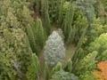
Eastwoodhill Arboretum
The 135-hectare arboretum is 34.6 km west of Gisborne on Wharekopae Road. Founded in 1910 by William Douglas Cook, it became his life’s work. In 2011 it had more than 15,000 trees, shrubs and climbers, and was home to 40 species of native and exotic birds. It featured 25 kilometres of graded and marked walking tracks.
Rēre
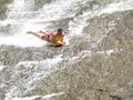
Locality 47 km west of Gisborne on Wharekōpae Road. The Rēre rock slide is a natural 60-metre water slide that every summer attracts visitors bearing boogie boards, tyre tubes and inflatable mattresses. The impressive Rēre Falls are a few hundred metres further north.
Ngātapa
A 703-m hill north-west of Rēre, and 25 km north-west of the locality also called Ngātapa. In November 1868 prophet and military leader Te Kooti and his followers fortified this sloping summit after an engagement at Mākaretū, near Rēre. The attackers, comprising government forces and Māori from neighbouring tribes, eventually captured the pā. Te Kooti and some of his followers escaped, but many others were taken prisoner or executed.
Manutuke
Settlement 13.5 km west of Gisborne with a 2013 population of 522. Manutuke is the heart of the Rongowhakaata iwi (tribe). Its meeting houses are graced with some of the most outstanding examples of traditional Māori carving in New Zealand. Te Mana-o-Tūranga at Whakatō marae and Te Poho-o-Rukupō at Manutuke marae are exemplars of the style of Raharuhi Rukupō, a descendant of Rongowhakaata, who was a leader and carver in the mid-19th century.
The Manutuke area includes many historic buildings such as the Anglican Church Toko Toru Tapu, which was built in 1913 on the site of an earlier church. The interior is adorned with whakairo (Māori carvings). These early churches are notable for the innovative ways in which Māori builders and artists wove together Māori and European architectural and cultural traditions.
The site of Tāpui pā is on Taurau Valley Road, on private property. The river pā, which was reinforced when civil war threatened in 1865, has deep ditches and high embankments, and is in a good state of preservation.
Tiniroto
Locality on the inland road from Gisborne to Wairoa, 59 km south-west of Gisborne and 43 km north-east of Wairoa. The road from Gisborne, which leaves State Highway 2 shortly after Matawhero, climbs over what is locally known as Gentle Annie then, via Waerengaokurī, descends into the valley of the Hangaroa River, a tributary of the Wairoa River, which drains the whole of the inner south-west part of the East Coast region. Doneraille Park, 10 km before Tiniroto, is a reserve with camping. The name Tiniroto (many lakes) was coined by ethnographer and surveyor general S. Percy Smith, in reference to the numerous small lakes in the district. The 50-hectare Hackfalls Arboretum in Tiniroto was established by local farmer Bob Berry in the 1950s, and has about 3,500 mostly exotic trees.
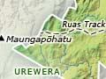
Rua’s track
A 25-km tramping track into Urewera National Park from the upper reaches of the Hangaroa River, starting at the end of Waimaha Road. The track is named for Rua Kēnana, a Tūhoe prophet and religious leader.
Muriwai
Settlement 25 km south of Gisborne on State Highway 2, home to Ngai Tāmanuhiri, the smallest of the Tūranga iwi. Close to the village is the Wherowhero Lagoon where, according to tradition, the Horouta waka (canoe) lies. The white cliff headland named Young Nick's Head by Lieutenant James Cook is a stone’s throw from Muriwai. While Cook named it after his surgeon’s boy, Nicholas Young, who first saw land on 6 October 1769, it is known to Ngāi Tāmanuhiri and other iwi as Te Kurī-a-Pāoa, meaning the dog of Pāoa, as this was what it was said to look like.
Wharerātā Range
Rugged hill country, in 2011 mostly planted in exotic forest, adjoining the coast south of Muriwai. It is crossed by both State Highway 2 and the Napier–Gisborne railway, the latter with the aid of many tunnels. At the summit on State Highway 2 a lookout offers a majestic view of Poverty Bay. On the coast are Whareongaonga, the landing place in 1868 of Te Kooti and those who escaped with him from Wharekauri (the Chatham Islands), and Paritū, a bluff marking the southern boundary of the Horouta waka district.