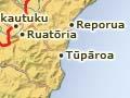

Tikitiki
Settlement on the Waiapu River, 145 km from Gisborne, 20 km from Ruatōria, and 24 km from Te Araroa. From Te Araroa State Highway 35 climbs over hills to the Maraehara River valley and then the Waiapu River valley.
The town’s name derives from Māui-tikitiki-a-Taranga (Māui wrapped in the topknot of Taranga), the full name of the demigod Māui. Tikitiki’s jewel is St Mary’s Anglican church, which combines Māori architectural design with intricate carvings, tukutuku (woven panels) and fine stained-glass windows. It is considered one of the finest Māori churches in New Zealand. Completed in 1926 under the direction of Apirana Ngata, it is a memorial to Ngāti Porou soldiers who fought and died in the First World War.
Above the church is Pukemaire, once a fortified pā, where one of the last confrontations between Pai Mārire and Ngāti Porou forces took place in 1865.
Rangitukia is 6 km down the Waiapu River from Tikitiki along Rangitukia Road. In the 2000s a local business ran horse treks.
Waiapu River
The Waiapu River is the major artery and spiritual heart of the Ngāti Porou landscape. Its two principal tributaries, the Mata and Tapuaeroa rivers, join to form the Waiapu just west of State Highway 35, near the junction with the road to Ruatōria. The Waiapu enters the sea just past Rangitukia. Its catchment covers the greater part of the region north of Tokomaru Bay. The clearance of forest in its headwaters has led the river to flood repeatedly, and has caused one of the highest sediment yields in the world (36 million tonnes, approximately one-sixth of the annual sediment flow in all New Zealand river systems).
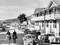
Ruatōria
Township 128 km north of Gisborne, 3 km off State Highway 35, with a 2013 population of 750. At first it was known simply as the Cross Roads. In 1913 it was named Ruatōrea (more correctly Rua-a-Tōrea, the storage pit of Tōrea), but was altered to the current spelling in 1925. It is adjacent to the Waiapu River, which was bridged at nearby Rotokautuku in 1916.
Ruatōria became the ‘capital’ of Ngāti Porou territory once the road became the main link between the coast and Gisborne in the 1920s, and remains the principal service town for the coast north of Tokomaru Bay.
The district was home to politician and statesman Apirana Ngata and Victoria Cross winner Te Moananui-a-Kiwa Ngārimu. The principal marae is at Mangahānea, a few kilometres east of the township. Its meeting house, Hinetāpora, dates from 1896. Ngata’s homestead, known as ‘the Bungalow,’ is at Waiōmatatini, 13 km downriver.
Nāti butter
From 1925 Ruatōria was well-known for its Ngāti-Porou Co-operative Dairy Company, and the Nāti-branded butter its factory produced won the national award for the best butter for several years in succession. The cooperative was a predominantly Māori venture and its financing, which included buying herds for intending suppliers, was distinctive. It began in the 1925–26 season with 58 suppliers and an output of 61 tons of butter; within 10 years it had 377 suppliers and an output of 743 tons. The company featured in the 28 May 1952 issue of The Weekly News. The article said: ’It is staffed and managed entirely by Maoris, and 90 percent of its cream supply comes from farms under Maori ownership or management.’1 The building still stands, but with a declining milk supply the factory closed in 1954.
Port Awanui
Settlement on the coast approximately 15 km from Ruatōria via Waiomatatini. Port Awanui grew from a shore whaling station in the 1840s to a township with shipping, a school, courthouse, post office, two hotels and the headquarters of Waiapu County Council. However, the arrival of motor vehicles and the building of the Gisborne–Te Araroa road in the 1920s meant the port was bypassed. The police station was transferred to Tikitiki in 1935 and after severe flooding in 1938 the port ceased operation.
Tūpāroa, 13 km down the coast from Port Awanui, was also a port where wool bales were loaded during the coastal shipping era. In 2011 the road to Tūpāroa from Ruatōria traversed a riverbed for several kilometres.
Hikurangi
Mountain (1,752 m) on a spur of the Raukūmara Range, inland from Ruatōria. Hikurangi is the highest non-volcanic summit in the North Island, and is of great cultural, spiritual and physical significance to Ngāti Porou. It overshadows the adjacent summits of Whanokao (1,428 m), Aorangi (1,272 m), Wharekia (1,106 m) and Taitai (678 m). Taken as a whole, the group provides an awe-inspiring vista, which has long evoked the admiration of Ngāti Porou.
On the mountain are nine whakairo (carved sculptures), erected to commemorate the millennium in 2000, which depict the tipuna (ancestor) Māui-tikitiki-a-Taranga and his whānau. Māui is said to have fished up the North Island, and his canoe Nukutaimemeha lies petrified near the summit of the mountain. These massive whakairo are a tribute to the heritage and art of Ngāti Porou.