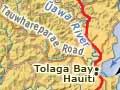

Tolaga Bay
Township with a 2013 population of 768, 55 km north of Gisborne and 35 km south of Tokomaru Bay on SH35. The district was known to its original inhabitants as Ūawa. Around the 16th century, Hauiti established himself as chief in the area and today his descendants are known as Te Aitanga a Hauiti (the descendants of Hauiti).
Cook’s visit
British explorer James Cook and the crew of the Endeavour took on board fresh water, cut wood, fish and kūmara (sweet potato) during their visit in October 1769. Cook named Ūawa Tolaga Bay, possibly misinterpreting a word (te raki) referring to a north wind blowing into the bay.
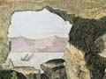
Cooks Cove, reached by a 5.8-km walkway from the south side of Tolaga Bay, is the actual site of Cook's landing. The Endeavour was hauled ashore to clean two years’ worth of weed and barnacles from its hull. The ‘hole in the wall’, a natural arch in a rock wall, which was drawn by Herman Spöring, an assistant of botanist Joseph Banks on the Endeavour, can still be seen. A memorial put up in 1966 commemorates the visit.
History of the township
The township was established in 1875 on the Ūawa River, and a post office opened in 1877. It began as an area of 252 acres (102 hectares), with an estimated population of 800, 52 of whom were Pākehā settlers and the rest Māori living at Hauiti on the south side of the river. In 1894 it was named Buckley, after Patrick Buckley, the then colonial secretary, but the name was rarely used. The river was crossed by punt until a 175-metre-long bridge was built in 1905 – its steelwork was constructed by the Elmira Bridge Company of New York.
Opening of the Ūawa bridge
The bridge across the Ūawa River was opened on 24 April 1905: ‘The march proceeded across to the Hauiti side, where they were welcomed by a local chief … Rutene … then an unrehearsed incident occurred. The natives, who had somehow been omitted from the programme, seized the opportunity as the party reached the Hauiti or Maori side … and the procession was confronted by a party of a dozen or more warriors who, headed by an elderly wahine, struck up an enthusiastic haka of exultation. The performance was greeted with a round of cheers.’1
Tolaga Bay was the headquarters of Uawa County, which was established in 1918 and merged back into Cook County in 1964.
A weekly coach service from Gisborne started in 1887. The Tolaga Bay Co-operative Dairy Company was established in 1912, and a butter factory was built on the south bank of the Ūawa River above present-day Hauiti marae. At its peak in the 1930s it had over 120 suppliers and an annual production of 700,000 pounds (317,515 kilograms). The factory closed in 1959.
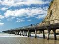
Shipping goods over the Ūawa River bar became increasingly difficult as vessels got larger and the river silted owing to forest clearance in the headwaters. The 660-metre-long Tolaga Bay wharf, started in 1926, was completed three years later. Metal for the structure was brought by barge from Napier. Supplies of fertilizer, petrol and beer were brought in via the wharf from boats servicing the coastal reaches. Outgoing from the wharf was maize, livestock, dairy products and wool. The wharf, which still stands, was closed to shipping in 1967.
The wharf is the second longest in New Zealand. In the early 2000s its deterioration led to the forming of a ‘Save the Tolaga Bay Wharf’ committee, which raised funds to restore or at least prolong the life of the wharf.
In the early 2000s the township had shops and accommodation. There was a resident doctor at the Ūawa Health Clinic and a motor camp near the wharf. Tauwhareparae Road linked inland farms with the township.
Anaura Bay
13 km north of Tolaga Bay, then 7 km via a side road, Anaura Bay is a beautiful bay with a 2-km curve of sandy beach backed by bush-covered hills. This was once the domain of Tautini, a grandson of the chief Hauiti from Ūawa, who lived at Toiroa, a pā on the ranges between Anaura and Tokomaru bays. Tautini married Hinetamatea, whose name the meeting house at Anaura Bay bears.
On 21 October 1769, James Cook entered the bay to be greeted by Māori in canoes. On shore he recorded in-depth descriptions of Māori horticulture. The crew of the Endeavour were amazed at the orderliness, regularity and number of gardens in the area.
In addition to the marae and a sprinkling of houses, a full-time camping ground and a seasonal Department of Conservation camping area are regularly visited by holidaymakers from Gisborne and further afield. Anaura Bay Scenic Reserve encompasses 225 hectares; its walkway offers views of both beach and bay. Just to its north are Waipare and Nuhiti scenic reserves.