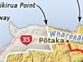
Pōtikirua
Pōtikirua Point is the northern boundary marker of the Ngāti Porou tribal district. It is on the coast between Matakaoa Point and Cape Runaway, part of an isolated block of volcanic rock which stretches between the two promontories. Nearby Lottin Point (Wakatiri), with majestic scenery and a rocky shoreline, attracts surfcasters, divers and people fishing from boats. There are many historic pā sites, and stone rows that mark off early Māori gardening plots.
Pōtaka
The closest settlement to Pōtikirua, just under 6 km inland, 197 km from Gisborne and 129 km from Ōpōtiki on State Highway 35. It is home to the hapū Te Whānau-ā-Tāpaeururangi. It has a school, marae and cluster of houses.
Hicks Bay
Settlement 180 km from Gisborne and 146 km from Ōpōtiki on State Highway 35. Zachariah Hicks, an officer on James Cook’s ship, Endeavour, sighted the bay on 31 October 1769. It lies between Matakaoa Point and Haupara Point, and is also known as Wharekāhika, the name of the river that flows into the bay.
A wharf but no roads
The wharf at the western end of Hicks Bay is a reminder of times when travel and transport in the region were by sea rather than by land. The wharf was upgraded to serve the freezing works built at Hicks Bay in 1920. However, with few roads to transport livestock to it, the works went out of business in 1926.
In 1865, when followers of the Pai Mārire religion, who supported Māori self-determination, invaded the region, two pā on Matakaoa Point were modified for musket fighting. St Barnabas Church, which probably dated from the same period, was destroyed by a storm in 1974. The present St Barnabas, combining traditional Māori and modern elements, opened for worship in 1979.
Wharekāhika Native School opened in 1887 and, along with other native schools, was integrated into the main public school system in 1969. Te Kura Kaupapa Māori o Kawakawa mai Tawhiti, a Māori language immersion school, operated in Hicks Bay in the 2000s. Nearby Matakaoa had its own school between 1921 and 1939.
Tūwhakairiora meeting house was completed in 1955 as a war memorial. Some of its carvings were made in 1872 for an earlier house.
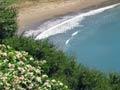
Onepoto Bay
At the southern end of Hicks Bay, before State Highway 35 climbs the ridge behind Haupara Point, a side road skirts a small headland to reach Onepoto Bay. Baches and holiday houses abut the safe, sandy beach. Boats can be launched off the sand and there is often excellent surfing.
Pukeamaru Scenic Reserve
A tract of native forest between the Wharekāhika and Karakatūwhero rivers; its highest points are Pukeamaru (990 m) and Harakeke (818 m).
Te Araroa
Settlement 12 km from Hicks Bay and 169 km from Gisborne. The post office was first called Wharekāhika (as in Hicks Bay) and the town was named Kawakawa-mai-i-Tawhiti (Kawakawa from afar), but Te Araroa became the name for both in 1888, partly to avoid confusion with Kawakawa in Northland. It is just west of the mouth of the Awatere River, first bridged in 1962.
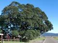
A pōhutukawa tree, reputed to be the oldest (more than 600 years) and largest in New Zealand, stands in the grounds of Te Kura-a-Rohe o Te Waha o Rerekohu school. Rerekohu was a famous tipuna (ancestor) of the region and his food was stored in a pātaka (store house) beside the tree.
Te Araroa was the home of the famed Ngāti Porou tipuna Tūwhakairiora. A fighting leader, he became chief of all the subtribes of northern Waiapu through a series of campaigns.
A township was established at Te Araroa in 1890. It was the headquarters of Matakaoa County, which existed from 1920 to 1965, but went bankrupt and was governed by a commissioner from 1933 until its dissolution. Te Araroa’s population was 500 in 1951; from the 1960s it fell, as did that of the district, as the road link to Gisborne improved.
In the 2000s Te Araroa was a popular stop for travellers on State Highway 35. Nearby Punaruku beach has safe swimming, surfing and shore fishing. Whetūmatarau – a prominent escarpment and pā site overlooking the township, which has expansive views – can be reached via a bush climb.
Nearby Hekawa was a whaling station in the 1830s, and a mission station was established there in 1843.
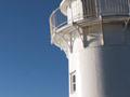
East Cape
A 21-km drive through the traditional territory of Te Whānau-ā-Hunaara hapū to East Cape, and a climb of 700 steps, leads to the most easterly lighthouse on the New Zealand mainland. The lighthouse was first established in 1900 on nearby Whangaōkena, or East Island as James Cook named it, judging, correctly as it turned out, that it was the most easterly point of the land mass he had recently encountered. With landslips threatening the lighthouse, it was moved to the mainland in 1922.