


He kōrero whakarapopoto
Early surveying
From the 1870s the government was New Zealand’s main provider of surveying and mapping services. Surveyors measured points and distances on the ground and staked out areas, so settlers could buy land, and accurate maps could be made.
In the late 19th century, the most accurate way to survey and map the land was by first establishing a triangulation network – a network of triangles that covered the whole country. Other points could be located in relation to these.
However, a major triangulation was slow and expensive. Instead the government divided the land into areas called meridional circuits. These had one known point within them, from which other surveys could be done.
The great triangulation
At the start of the 20th century, the government decided they needed a national triangulation network. They did a triangulation of the North Island between 1909 and 1938, and of the South Island between 1938 and 1942.
Aerial photography
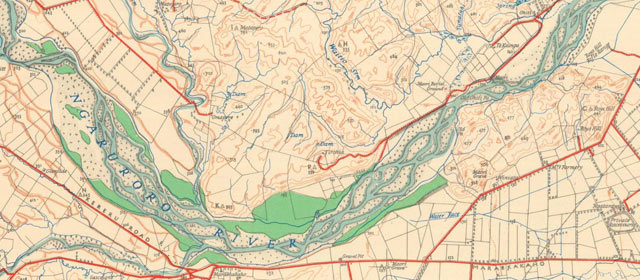
Aerial photography made it much faster to map the land than surveying it on the ground. From the 1930s, the government made a series of topographical maps – maps that show the contours of the land – covering all of New Zealand. A technique called photogrammetry allowed staff to view aerial photos as if they were three-dimensional, and make accurate topographical maps.
Orthophotos
Aerial photos have distortions in them, because of the curve of the earth’s surface and the angle of the camera. Orthophotos are aerial photos with the distortions corrected. Other information such as property boundaries can also be added.
Types of maps
A range of different types of maps have been made in New Zealand.
- Travel maps show the country’s roads – they became more important as more people owned cars.
- Street maps of towns and cities were published by the government and private companies.
- Atlases included school atlases, national atlases and a historical atlas.
New technology
From the 1970s, satellite images of New Zealand were produced. Global positioning systems (GPS) are used to locate points on the earth in relation to satellites.
Land information today
In the 1980s, the government’s surveying, mapping and land information services were combined in the Department of Survey and Land Information. In 1996, this was split into two organisations – Land Information New Zealand (LINZ) and Terralink.