


The great triangulation
By 1900 problems with the adopted system were becoming apparent. While it allowed for relatively rapid settlement, and provided accurate surveys within each meridional circuit, the lack of a primary national triangulation created problems for any survey that crossed circuit boundaries and made it difficult to provide accurate maps on a national scale. The meridional circuit was also treated as a flat plane, without corrections for the earth’s curvature.
The need for a primary triangulation was generally accepted by the early 20th century. This began in 1909 with the establishment of a baseline in the Wairarapa. Eight baselines, a fundamental requirement of the triangulation network, were established throughout the country between 1909 and 1947. Work continued sporadically on the great triangulation (later known as the geodetic triangulation) of the North Island until it was completed in 1938.
Work began on the South Island geodetic network in 1938. The triangulation of the North Island had enabled topographic maps to be quickly collated for military purposes. While the First World War had halted triangulation work, the threat of possible invasion during the Second World War meant that work continued on the South Island survey, extending into Otago and Southland during 1940–42.
Fieldwork
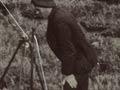
The geodetic triangulation was a huge undertaking. First, an initial reconnaissance was done and possible stations selected, generally on top of hills or mountains. Then trigonometric stations needed to be physically established, which entailed carrying timber and other equipment in to the site. For sites in the bush, trees had to be cleared, and bush along the lines of the rays to be observed had to be cut back, leaving a space 3 metres below the line of sight and 6 metres wide.
Once this was done, the surveyor could set up at the station, take the necessary observations, and move on to the next station. Where access was difficult and weather was bad, it could take 20 to 30 days to complete just one station’s observations.
Round, through or over
Staff measuring baselines sometimes met with obstacles, including barbed-wire fences, roads, railways, rough ground and large boxthorn hedges. When the Matamata and Waitematā baselines were re-measured in the 1940s, development around them meant that some deviations of the baseline were needed. Sometimes teams decided not to deviate: on one occasion a pig sty was moved out of the way, and another time the tape was carefully threaded through a hole in the side of a hen house.
Progress speeded up when night observations were introduced from 1930. Taking observations of lamps at the stations proved more accurate and faster, as the atmosphere was generally clearer at night. However night observations increased the number of staff needed, as someone had to be at each station at the same time, to light the lamps.
The final fieldwork for the geodetic triangulation, done in 1947–49 with equipment borrowed from Tanganyika (now Tanzania), established the three baselines in the South Island. Two baselines in the North Island, Matamata and Waitematā, were re-measured to ensure standardisation throughout the network.
Geodetic Datum 1949
The geodetic triangulation established the Geodetic Datum 1949 (NZGD49). A geodetic datum is a mathematical model approximating the curved surface of the earth which enables consistently accurate calculations of area and position. On the land this model is represented physically by points such as trig stations, whose positions have been accurately measured in terms of the datum.