Ashburton
Second-largest urban centre in Canterbury, 85 km south-west of Christchurch. The population in 2013 was 16,903. The site was originally a treeless plain, but the Ashburton Domain is now beautifully planted.
An accommodation house was built on a ferry reserve on the Ashburton River bank in 1858. The town, surveyed in 1863–64, served local farms. Industries also sprang up, including flour mills, dairy factories, freezing works, brickworks, a glass works and a motor-body works. Grain stores and stock and station agencies lined the main road and railway line. A stretch of the Tinwald–Mt Somers railway line, which closed in 1967, is kept at the Plains Vintage Railway and Historical Museum south of the town.
Mayfield
Settlement 35 km north-west of Ashburton. For many years Mayfield held the largest A & P (Agricultural and Pastoral) show outside Christchurch.
Rakaia
Farm-service township 30 km north-east of Ashburton. Between 1991 and 2013 its population rose from 762 to 1,113. The town grew on the south bank after the Rakaia River was bridged in 1878. A leaping salmon sign on State Highway 1 tells travellers that it is a fishing centre.
Ashburton River
90-km river that flows in two main branches across the Canterbury Plains. The south branch rises in small glaciers on the Arrowsmith Range. The north branch drains foothill ranges east of the Lake Heron basin. A group of huts at the river mouth, known by the river’s Māori name, Hakatere, developed from the 1900s. Another group is at Wakanui, just north of Hakatere.
Barrhill
Farming locality 17 km north-west from Rakaia. John Cathcart Wason took up the Corwar run in 1870, and then laid out a village in the manner of an English estate. After he sold up in 1900, the village disappeared. Trees, a church and schoolhouse remain as reminders of Wason’s failed vision.
Methven
Town 34 km north-west of Ashburton and 94 km south-west of Christchurch. Methven stands on the high plains at a point where six roads converge. Between 1880 and 1976 it was the terminus of a branch railway from Rakaia. Like other rural service towns in the region, Methven declined during the 20th century, but the opening of the Mt Hutt skifield reversed the downturn. Between 1991 and 2013 the permanent population increased from 978 to 1,707.
Mt Somers
Tiny settlement near the foot of Mt Somers itself, 48 km north-west of Ashburton. Coal, building stone, silica sand and lime were mined in the area, and the town was linked to Tinwald by rail. On Mt Somers there are reserves and popular walking tracks.
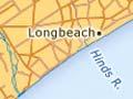
Longbeach
Farming locality 24 km south-west of Ashburton. In the 19th century, John Grigg aimed to make his 13,000-hectare property Longbeach the best farm in the world, by draining large swamps near the Hinds River. Grigg also helped start the meat-freezing industry in Canterbury. His statue stands in Ashburton.
On location
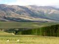
The Methven-based Edoras tour offers fans a chance to visit the Lord of the rings location in the Rangitātā valley near Mt Potts. The snow-capped mountains and vast tussock plains featured in the movie trilogy, are now a backdrop for souvenir photographs of fans holding replica swords.
Canterbury Bight
Coastline between Banks Peninsula and the low headlands near Timaru. The shingle beach has been known as the Ninety Mile Beach since the 19th century. The only settlements are the clusters of fishing huts at the mouths of the Rakaia, Ashburton and Rangitātā rivers.
Highbank
Hydroelectric power station 11 km north-east of Methven. Opened in 1945, it is fed from the 66-kilometre Rangitātā diversion race, which ends at the top of a terrace above the Rakaia River. The station has a head of 104.2 m and a capacity of 25,200kW.