Waiau
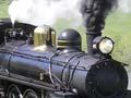
Settlement situated on the north bank of the Waiau River on the inland road to Kaikōura, 23 km north-east of Culverden. Waiau made the classic rural Canterbury shift from accommodation house to township. The river was bridged in 1883. In 1919 Waiau became the terminus of the branch railway from Waipara (now closed), but by then it had been eclipsed by Culverden. It has survived as a rural service centre.
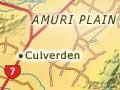
Culverden
Township 97 km north of Christchurch and 23 km south-west of Waiau, with a population in 2013 of 426. The population of the Amuri district, of which Culverden is the chief service centre, increased between 1996 and 2006 from 1,713 to 1,950, thanks in part to extended irrigation on the Amuri Plain.
Culverden became a railhead for the old Waiau branch line in 1886. The saleyards, long crucial to the farm economy of the Amuri, were built two years later. From 1890 until 1989 Culverden was the seat of the Amuri County Council.
Lowry Peaks Range
Rugged range of hills, crossed by a single road between Cheviot and Culverden, which separates the Amuri and Cheviot basins.
Balmoral Forest
One of Canterbury’s largest exotic forests, this was planted on poor land on the north bank of the Hurunui River, but suffered damage from fire in 1957 and from wind in 1975. After the last windblown logs had been railed out, the Waiau branch line, the last in Canterbury, was closed in 1978. There is a popular picnic and camping area on the southern side of the forest, by the Hurunui River.
Hawarden
Settlement 26 km south-west of Culverden, 7 km off State Highway 7. Back-country roads to Lake Taylor and the head of the south branch of the Hurunui begin at Hawarden.
Waikari
Settlement straggling along the base of a limestone ridge on the inland side of the Weka Pass, 8 km south-east of Hawarden. First settled in the 1860s, it grew after the railway had been built through. At nearby Pyramid Valley, a large deposit of moa bones was discovered in 1937.
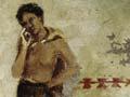
Saving or spoiling?
Ancient Māori rock art in a limestone shelter at the Weka Pass is protected against vandals by a floor to ceiling fence. But archaeologists, who established the value of the drawings, were the first vandals. In 1929 the director of the national museum had the drawings over-painted in red and black house paint to make them more visible.
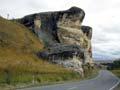
Weka Pass
The road and railway from the northern end of the Canterbury Plains into the Amuri district passes over a low point in limestone hills known as the Weka Pass. Rock art on the walls of limestone overhangs dates from more than 500 years ago. The pass was used in the early 1860s by the first gold miners heading for the West Coast over Harper Pass, and a little later by wagons bringing out the first of the Amuri wool clips.