Browning Pass
One of the lowest of the passes across the Southern Alps. It leads from the Wilberforce River, a tributary of the Rakaia River, to the Arahura River. A Māori route to the West Coast’s pounamu (greenstone) rivers, the pass was also used after gold was discovered on the West Coast. But the track cut during the 1860s fell into disuse, and most who cross the pass today are trampers on the Three Pass Trip (across Harman, Whitehorn and Browning passes) from the headwaters of the Waimakariri River.
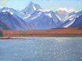
Lake Coleridge
Long, narrow 36-sq-km lake in a glacial hollow in the upper Rakaia valley, 510 m above sea level. Lake Coleridge water flows through the country’s first large state hydroelectric power station, built between 1911 and 1914. Water from the Harper, Acheron and Wilberforce rivers was later diverted to flow through the lake and powerhouse. Its nine generators produce 34,500kW. The lake is popular for fishing and boating.
Mt Algidus
Sheep run between the Rakaia and Wilberforce rivers. Mt Algidus was called Rakaia Forks when it was taken up by William Rolleston in 1861. It became famous after the publication of books by Mona Anderson, who lived on the property. A river rules my life (1963) and The good logs of Algidus (1965) are classics of Canterbury high-country life.
The high country
In A river rules my life, Mona Anderson describes her first impressions of the Mt Algidus high-country station: ‘The house lay in a sheltered little basin and from the back door I looked out over the Wilberforce, still in one of its quieter moods, to Mt Oakden, a scarred mass of ancient rock 5,000 feet high. … In the damp morning air [the mountains] looked close and enormously tall so that I wondered if the sun would ever get over them.’ 1
Rakaia River
The largest of Canterbury’s rivers. It runs for 145 km from the Lyell and Ramsay glaciers to the sea. Its main tributaries are the Wilberforce and Mathias. The highest peak on the Rakaia divide is Mt Whitcombe (2,638 m). In its upper reaches, the Rakaia valley has landforms shaped by the great glaciers which formerly filled the valley. The river is subject to a water conservation order.
Arrowsmith Range
High range lying east of the main divide between the Rakaia and Rangitātā rivers. The highest point, Mt Arrowsmith, is 2,781 m. Small glaciers feed the South Ashburton, Cameron and Lawrence rivers.
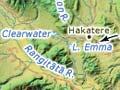
Lake Heron
Lake between the Old Man and Mt Taylor ranges to the east, and the Arrowsmith Range to the west. It drains into the Rakaia River. Other smaller lakes nearby – Clearwater, Camp and Emma – are known with Lake Heron as the Ashburton lakes. In 1934 sites at Clearwater were leased and small holiday houses built. Lake Heron is an important habitat of the endangered southern crested grebe.
Mt Hutt
Mountain rising abruptly from the plains to 2,185 m on the south side of the Rakaia Gorge. A basin on the south-eastern side is now a commercial skifield.
Rangitātā River
121-km river that separates mid-Canterbury from South Canterbury. The Clyde and Havelock rivers join near Erewhon Station to form the Rangitātā. The Rangitātā diversion race supplies irrigation water to the plains inland from Ashburton. It also feeds the Highbank power station 60 km away on the Rakaia River. The river is protected by a conservation order.