
Palmerston
Palmerston is the centre of East Otago, with a 2013 population of 795. It is 59 km south of Ōamaru and 56 km north of Dunedin, at the junction of State Highway 1 with the ‘Pigroot’ (State Highway 85), originally a route to the Central Otago goldfields. Puketapu (343 m) is capped by a memorial to Liberal Party politician Jock McKenzie, who represented the district in Parliament for many years. An opencast gold mine opened at Macraes Flat, 32 km inland, in 1990.
Shag Point
Shag Point, 10 km north of Palmerston, has been the site of Māori settlement, coal mining and holiday houses – as well as shags, seals and rare yellow-eyed penguins. A moa-hunting site was situated at the mouth of the Shag River.
Waikouaiti
Waikouaiti, 45 km north of Dunedin, had a 2013 population of 1,125, and promotes itself as the ‘birthplace of Otago’. It was a long-standing Māori settlement. Whaler Johnny Jones established a shore station at nearby Karitāne in 1837, and a farm and homestead at Matanaka in 1840. Some of the farm buildings were open to the public in the early 2000s.
A new road was built in 1864 and the town developed alongside it. In 1866 the settlement became the borough of Hawksbury (also the name of its river at the time). It was called Waikouaiti from 1909. The town has a small museum, a racecourse and a golf course.
King of Karitāne
Karitāne gave its name to nurses who were trained to work with mothers and newborn babies under Truby King’s scheme. The first Karitāne hospital was, unsurprisingly, in the town of the same name. King had built a house, Kingscliff, there when he was superintendent of Seacliff mental hospital.
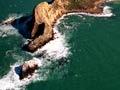
Karitāne
Karitāne, 34 km north of Dunedin at the mouth of the Waikouaiti River, had a 2013 population of 360. The furthest point of the promontory, Huriawa (the locality’s original name), was a stronghold of the Ngāi Tahu chief Te Wera. The location has a fresh water spring, and was the site of an unsuccessful intra-tribal siege. In the 2000s it was a historic reserve.
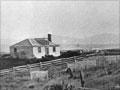
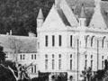
Seacliff
Settlement just east of the coast road between Waitati and Waikouaiti. The former Seacliff mental hospital, which opened in 1884, was built on a side road. The hospital had over 500 inmates at its peak; the main building closed in 1958.
The site is now Truby King reserve, named after Seacliff’s first superintendent. A scandal over the construction of the building – which was built on unstable ground – ruined the career of architect Robert Lawson. A replacement hospital, Cherry Farm, opened in 1954 on State Highway 1 just south of Waikouaiti. It closed in 1992.
Confined at Seacliff
In 1942, in one of New Zealand’s worst fire disasters, 37 out of 39 patients in the locked Ward Five of Seacliff hospital died. For periods between 1947 and 1955 Janet Frame, one of New Zealand’s most accomplished writers, was a patient at Seacliff. She had been mistakenly diagnosed as schizophrenic.
Warrington
Settlement 27 km north of Dunedin, between Blueskin Bay and the ocean, with a 2013 population of 450. Sand dunes open onto an expansive ocean beach, part of which is the spit separating the bay from the open sea.
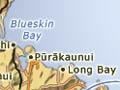
Waitati
With a 2013 population of 513, Waitati sits on Blueskin Bay, 20 km north of Dunedin. The highway north from Waitati to Waikouaiti crosses hill country. Known as the Kilmog, this stretch of road long had a reputation for winter closures and difficult driving conditions.
On Māpoutahi peninsula, past the holiday and retirement settlement of Doctors Point, are the remains of a large fortified pā. It was the site of a major battle, probably in the mid-1700s.
Whalers named the area Blueskin after a much-tattooed Ngāi Tahu chief. An eco-sanctuary has been developed at nearby Ōrokonui. On the coast north of the road to Port Chalmers are two other holiday settlements, Pūrākaunui and Long Beach.