

Milton
With a 2013 population of 1,926, Milton is the centre of the Tokomairiro district, broadly the catchment of the Tokomairiro River, which runs between the much larger Taieri and Clutha rivers. Milton is a service town for the district, which previously had a separate status as Bruce county. Milton was originally known as Mill Town after its large flour and oat mill. That mill later became part of the Bruce woollen mill, which was the town’s principal employer until it closed in 1999. Another business, Bruce Woollen Mill, operated from the mill buildings in the 2010s.
Union Street, the 2.25-kilometre main street, rivals Carterton in the North Island for its length relative to the town’s size. The town shares its name with 17th-century poet John Milton, and streets are named after British poets, or are poetically inspired.
Beach settlements
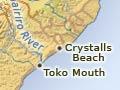
Toko Mouth and Chrystalls Beach are coastal holiday settlements. A 24-metre basalt column at Chrystalls Beach is known as Cooks Head.
Waihola
Settlement adjacent to a shallow lake of the same name on the Taieri Plain, 35 km south-west of Dunedin. Lake Waihola is popular for water sports. A lake crossing provided part of one route from Dunedin to the Tuapeka goldfield. The name is a dialect version of Waihora. There is a wildlife reserve at nearby Lake Waipori.
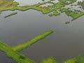
The Sinclair wetlands, between the two lakes, consist of over 315 hectares of lagoons, waterways and islands.
Lawrence
Lawrence is 92 km west of Dunedin by road on the Tuapeka River, a tributary of the Clutha/Mata-Au. It had a 2013 population of 417, down from 540 in 1996.
Lawrence developed in the 1860s gold rushes. Peel Street was the main street then; now it is Ross Place on State Highway 8. Two buildings date from 1866, five years after the original rush. Churches built to last came later – the Ōamaru stone Presbyterian church in 1886 and the brick Catholic St Patrick’s in 1892.
A settlement of Chinese miners just outside the town had 300 residents in 1870.
Beer from Lawrence’s Black Horse brewery, first set up in 1866, was ‘famed from Canterbury to Bluff’. The brewery closed in 1923. Several hectares of daffodils planted by the brewery attracted excursion trains and buses from Dunedin in spring. Today an annual arts festival each January draws visitors to the town with its attractive valley setting.
Gabriels Gully and Waitāhuna
4 km from Lawrence, in a side valley off the Tuapeka River, Gabriels Gully was the site of Otago’s first gold rush. Another mining site and gold settlement, Blue Spur, is nearby, and has a walking track with interpretive signs.
10 km south-east of Lawrence, another gold-rush locality, Waitāhuna, was home to a Chinese gold-mining settlement for a number of years from 1866. It had 150 residents in 1870.