
North Dunedin
Suburb north of the central city; site of the University of Otago, whose buildings dominate the area. The Dunedin Botanic Garden, established in 1863, separates the suburb from North East Valley. Logan Park is one of Dunedin’s main sports grounds.
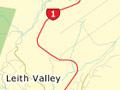
The Water of Leith, which flows through Leith Valley, along the western side of the Botanic Garden, and then through the university grounds, is named after a stream in Edinburgh, Scotland. The first exotic freshwater fish brought into New Zealand – brown trout – were released in the stream in 1869.
Scarfies
Otago University students are nicknamed scarfies, after the long scarves they wear in winter, which are blue and gold in support of the province’s rugby team. Scarfies is also the title of a 1999 movie, a comic thriller about five student flatmates who find a crop of marijuana being grown in the basement of their dilapidated Dunedin home.
North East Valley
Long narrow valley, previously on the main road north. North East Valley is on the road to Mt Cargill and an alternative route to Waitati. Annual competitions – in running, and in rolling Jaffa sweets – are held on Baldwin Street, the world’s steepest street.
Ōpoho
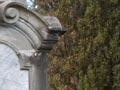
Suburb on the hill slopes either side of Signal Hill Road between North East Valley and the harbour, above the Northern Cemetery. The buildings of Knox College, dating from the first decade of the 20th century, stand out at the approach to Ōpoho.
The beautifully landscaped and cared-for cemetery was closed to burials in 1937. Signs direct visitors to the grave of Thomas Bracken, journalist and member of Parliament. Bracken composed the words of the national anthem ‘God defend New Zealand’, and the poems ‘Not understood’ and ‘Dunedin from the bay’. Part of the latter is quoted at Bracken’s Lookout in the cemetery.
There is also a memorial to Taranaki Māori from Parihaka who were imprisoned without trial in Dunedin from 1879. A number died and were buried in paupers’ graves.
Signal Hill offers extensive views over city and harbour, and is the site of a massive memorial commemorating the 1940 centennial of European settlement in New Zealand.
West Harbour
West Harbour, along the west side of Otago Harbour on the road to Port Chalmers, includes the suburbs of Burkes, St Leonards and (the largest) Ravensbourne, the site of a fertiliser works. A borough since 1877, West Harbour was incorporated in Dunedin city in 1963. Situated on terraces above the water’s edge, the expanse of houses is easy to miss from the harbourside highway. The suburbs have few shops or other facilities.
Mt Cargill and Flagstaff
Mt Cargill (675 metres) is the highest summit on the west rim of the harbour, and almost twice the height of the highest hill on Otago Peninsula. Another summit, Flagstaff (668 m) is north-west of the suburb of Wakari.
Town belt
Land was set aside as a town belt when Dunedin was first laid out, and became important for leisure and recreation as the town expanded. The western side in particular creates a park landscape for nearby houses. Below the belt, many of Dunedin’s most influential and wealthy early residents built on Heriot Row and Royal Terrace, in the angle formed by Pitt and London streets.
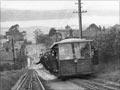
Māori Hill, Roslyn, Belleknowes and Mornington
These suburbs lie on the western side of Dunedin’s town belt, spreading along the ridge that overlooks the city. Their axis is Highgate and then Kenmure Road. Trams made these neighbourhoods easy to reach, and many streets became the preserve of affluent citizens.
Kaikorai Valley, Wakari, Halfway Bush and Brockville
Kaikorai Valley is an industrial area behind the Mornington ridge. Kaikorai Valley High School, later Kaikorai College, opened in 1958. On two hillsides above it, separated from each other by a deep ravine, large numbers of state (public) houses were built after the Second World War, enlarging the suburb of Wakari and forming the new suburb of Brockville. Halfway Bush, once a rural locality on a back road halfway to Taieri, is also now suburban.