
Otago Peninsula is the eastern flank of an extinct volcanic system. The highest summit, Mt Charles/Poatiri, reaches 408 metres. On the Otago Harbour side a sealed waterfront road links Taiaroa Head with Dunedin; on the remote ocean side, some of the roads are gravel. Dry stone walls, made of scoria, are a reminder of the Scottish origins of its early settlers. New Zealand’s first cooperative dairy company produced cheese from its factory on the peninsula in 1873. A separate county for many years, the peninsula joined Dunedin city in 1968.
Macandrew Bay
The road to Macandrew Bay was built in the 19th century with the help of prison labour, including Māori prisoners from Parihaka. A Māori name for the bay is Te Rotopāteke (bay of the brown duck). Craft shops and newer buildings sit alongside an old-style dairy (convenience store). The nearby Glenfalloch woodland gardens, with flowers and plants from all over the world, were developed by Philip Baring in the early 20th century.
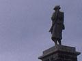
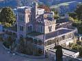
Highcliff Road and Larnach Castle
A soldiers’ memorial stands prominently above Highcliff Road. Camp Road leads to the substantial Larnach Castle, designed by Dunedin architect Robert Lawson for businessman William Larnach in 1871. Larnach named it, with extreme understatement, ‘the Camp’. Passing through a series of owners after Larnach’s suicide in 1898, it has belonged to the Barker family for over 40 years, and in the early 2000s was run as a tourist operation, function centre and hotel.
Broad Bay
Harbour ferries ran from Broad Bay (known to Māori as Oho Rahi) into Dunedin in the first 30 years of the 20th century. A number of business families, including the Speights beer barons, had holiday houses at Broad Bay. Building magnate James Fletcher erected his first house there in 1909; it is open to the public.
Portobello
The principal settlement for the peninsula’s farms and the site of its district museum. Early settler Walter Christie called his house Portobello after his Scottish birthplace and the name came to refer to the settlement. In 1904 a marine hatchery and biology station were established at nearby Quarantine Point; in 1951 they were taken over by the University of Otago. Since 1997 they have been complemented by a marine studies centre and aquarium.
Ōtākou
A long strip of homely, sometimes eccentric cribs (holiday houses), Ōtākou is an important Māori centre. It has a marae, church, and Tamatea meeting house. Te Rūnanga o Ōtākou has its offices here. The name itself is the basis of the name Otago.
Next to the meeting house is a substantial residence with a magnificent carved gateway. The cemetery behind the church includes the graves of many Ōtākou ancestors, including Ngāi Tahu leader Taiaroa, who died in 1863.
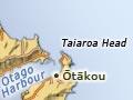
Taiaroa Head
At the entrance to Otago Harbour, Taiaroa Head has the remains of a Māori pā. The lighthouse dates from 1865; it is now automated and monitored from the adjacent signal station. Fortifications from 1885 – to ward off a possible foreign naval attack – were maintained until 1945. The disappearing gun has been restored.
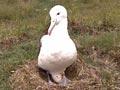
Taiaroa Head is a breeding reserve for the royal albatross. The first record of an albatross egg there dates from 1920, after forest was cleared. Albatrosses mate only in alternate years; each year no more than a dozen pairs raise their single chick here, from November to September. A yellow-eyed penguin reserve is located on the seaward side of the head.