The South Island’s longest river, and Otago’s main river, the Clutha River/Mata-Au runs from Lake Wānaka to its mouth on the coast south-east of Balclutha. Two-thirds of the Clutha’s water comes from the mountainous catchments of Lakes Wānaka, Hāwea and Wakatipu, and of the Shotover River.
Lake Wānaka is fed by the Makarora River to its north; the continuous stretch of water from the Makarora’s headwaters to the mouth of the Clutha is 338 km long. Though slightly shorter than the North Island’s Waikato River (354 km), the river discharges almost twice the volume.
Hundred-year floods
The two biggest floods on the Clutha were exactly a century apart. A massive flood on 14–16 October 1878 damaged or destroyed six major river crossings. Then a hundred years later, on 13–15 October 1978, the Clutha and a number of other southern rivers inundated a huge area, killing thousands of stock and forcing many people to evacuate their homes.
Tributaries
The Clutha’s principal tributaries are the Kawarau, which drains Lake Wakatipu; the Manuherikia, which drains one of Central Otago’s basins; the Pomahaka, which drains West Otago; and the Tuapeka. The name Clutha is a version of Clyde (a Scottish river); the Māori name is Mata-Au. The river was named Molyneux by British navigator James Cook.
Exploiting the river
In 1900 there were 187 gold dredges on the river. Steamers used to ply the lower river in the later 19th and early 20th century. There are hydroelectric power stations at Roxburgh (1956) and Clyde (1990). Later schemes to harness more hydroelectricity have been vigorously opposed, and have not proceeded.
Upper reaches of the river
The outlet from Lake Wānaka at Dublin Bay marks the start of the Clutha River. The Hāwea River, the outlet for Lake Hāwea, joins the Clutha 3 km downstream. In 1958 a control gate and a 30-metre earth dam were installed at the Lake Hāwea outlet, allowing the lake to rise by 18 metres to ensure a water supply to the Roxburgh hydroelectric station. When the water level falls an unattractive shore is exposed. The level of Lake Wānaka is also managed to ensure a water flow for the Clyde and Roxburgh power stations.
Naming Frame
Because of her desire for privacy, author Janet Frame changed her name to Nene Janet Paterson Clutha by deed poll in 1958. She chose the name Clutha because of the river’s significance to her creative imagination. (Nene was after the Māori leader Tāmati Waaka Nene, whom she admired; it was also similar to her childhood nickname, Nini.)
Clyde Dam, Cromwell Gorge and Lake Dunstan
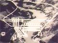
Controversy raged over the plan to build the Clyde Dam at the lower end of the 20-km Cromwell Gorge, flooding 86 hectares of apricot orchards. Cromwell town was to be flooded too, but would benefit from the construction of a new town, and the creation of a lake. Work started on the dam in 1981, and was finished by 1989. In 1993 the station was commissioned and Lake Dunstan (26 square kilometres) filled up.
Roxburgh Dam, Roxburgh Gorge and Lake Roxburgh
Stretch of the Clutha between Roxburgh and Alexandra. Lake Roxburgh, product of the Roxburgh dam, extends halfway up the gorge. To Māori the gorge was Kā Moana Haehae (the division of the waters). Since the 1998 Ngāi Tahu settlement this is the name of the bed of Lake Roxburgh.
Roxburgh was the first big power scheme in the South Island after the Second World War. The dam and power station were built between 1949 and 1956. A display on the east side of the river, titled ‘A town now gone!’, is at the site of the long-dismantled construction village.
The present-day village, on the west side of the Clutha just below the hydroelectricity station, was built by the government to house the engineers and others who managed the hydro dam. The power station is now operated remotely from Clyde, and most houses in the village are privately owned.
The lower Clutha
Beaumont
In the mid-1990s a petition against a proposed hydroelectric dam at Beaumont was signed by 26,000 people. The project didn’t proceed – but it was reconsidered in 2009, only to be shelved again in 2012.
Tuapeka Mouth
Farming settlement at the junction of the Tuapeka and Clutha Rivers, 35 km north-west of Balclutha and 14 km south-west of Lawrence. In the 2010s it was mainly known for its ferry, the sole survivor of a number of early Clutha River ferries. A punt is mounted on steel pontoons; wire ropes attach it to overhead cables, and the river current provides the power.
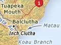
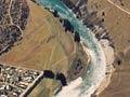
Inch Clutha
In its last kilometres below Balclutha the Clutha River divides into the Koau (west) and Matau (east) branches. The fertile Inch Clutha farming district lies between.