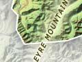
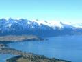
Lake Wakatipu
Lake Wakatipu is 290 square kilometres in area, and 377.5 metres at its deepest point. It occupies the valley carved by a former glacier, and has a distinctive zigzag shape, some 80 kilometres in length.
Māori tradition explains the lake – like the South Island’s other glacial lakes – as the product of digging by Rākaihautū, captain of the Uruaocanoe. The lake rises and falls around 12–20 centimetres every 52 minutes.
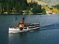
The paddle steamer Mountaineer operated on the lake until 1932. The TSS Earnslaw was launched in 1912. Since 1969 it has been used for lake cruises, with daily sailings.
Across the lake
The mountains of Cecil Peak (1,978 m), Walter Peak (1,689 m) and Mt Nicholas (1,459 m) are also sheep stations; Cecil Peak can only be accessed by water, and receives day excursions from Queenstown. A kauri tree planted at Walter Peak station on the shore of the lake in 1965 is believed to be the southernmost kauri in New Zealand.
The Remarkables
Photogenic mountain range rising steeply above the eastern shore of lower Lake Wakatipu, with much evidence of glaciation. Double Cone (2,324 m) is the highest point. Below it, on the eastern side of the range, is the Remarkables skifield.
Kingston
47 km from Queenstown at the southern end of the lake. From 1983 the Kingston Flyer ran summer train excursions to Fairlight, 14 km away along the only surviving stretch of the former railway line to Invercargill.
Kelvin Heights
Kelvin Heights and Jacks Point are upscale lakefront settlements. Deer Park Heights, between the two, was a location for the film trilogy Lord of the rings.
Dart and Rees River valleys
The glaciated valley at the head of Lake Wakatipu extends for about 10 km along the courses of the two rivers, between the Richardson Mountains and Humboldt Mountains. The rivers are braided across the valley flats. The striking mountain and basin landscape featured in the Lord of the rings films.
Glenorchy, 50 km from Queenstown on the east side of the lake’s northern tip, has about 500 residents and a number of cafes and bars. A wetland walk takes visitors across the river flats.
Paradise, 20 km north of Glenorchy, past trout-rich Diamond Lake, is the starting point for the round-trip Rees–Dart Track in Mount Aspiring National Park.
Kinloch, at the north-west corner of the lake, is a base for the Routeburn, Caples and Greenstone tracks, which cross the western ranges into Fiordland.
Shotover River
Tributary of the Kawarau River. In 1862 two shearers, Thomas Arthur and Harry Redfern, discovered gold at Arthurs Point, where the river emerges from the mountains.
Māori Point on the Shotover River takes its name from the 1863 gold find of Rāniera Ellison and companions. Moke Creek (a Shotover tributary), Moke Lake and Moonlight Creek were also the site of mining.
Today the Shotover is popular for adventure sports, in particular jet boating and white-water rafting through the Shotover canyon.
Skippers
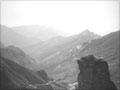
A remote goldfield at the junction of the Shotover and Skippers Creek. The perilous road to Skippers is popular with visitors. The road stops before the Skippers suspension bridge, 100 m above the Skippers or Shotover canyon, which offers access to the abandoned township.
In 1886 Bullendale, at the head of Skippers Creek, was the site of New Zealand’s first hydroelectric generator-powered crushing machines, designed to separate gold from quartz. However, they were unprofitable.