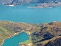
Lake Wānaka
One of the major glacial lakes of the Southern Alps, Lake Wānaka is 192 square kilometres in area, 45 km long and 6 km across at the widest point. 274 km above sea level, it has an estimated maximum depth of 311 m.
The lake is protected by the Lake Wanaka Preservation Act 1973, which established a group of guardians.
Māori origins
In Māori tradition, both Lakes Wānaka and Hāwea were gouged by the kō (digging stick) of the ancestor Rākaihautū. There is evidence of Māori settlements around both lakes, but they were abandoned by the 1840s.
Jewel of an island
From the 1920s Ruby Island, in Lake Wānaka, was the site of a cabaret used by parties from the mainland. One visitor described how ‘[i]n a little boat we floated to Ruby Island, and there peeped at the log cabin cabaret set in forest loveliness where the light-hearted dance the happy hours away’. 1
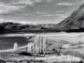
Rivers and islands
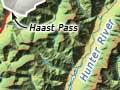
The most important rivers feeding the lake are the Makarora, which rises near Haast Pass, and the Mātukituki, which has its headwaters on Mt Aspiring/Tititea. The upper part of the lake occupies a single glaciated valley. The southern part of the lake has an irregular form, with a number of bays including Stevenson Arm, separated from the main body of the lake by a hilly peninsula; there are also several islands. Aggressive lake weed has been a problem since it was accidentally introduced in 1973.
Lakeside sheep stations include Glendhu, Cattle Flat and West Wānaka to the south-west, Mt Aspiring and Minaret on the west, and Makarora and Mt Albert to the north.
The town of Wānaka is located on Roys Bay; the lake’s outlet, into the Clutha River/Mata-Au, is at the head of Dublin Bay.
Thwarted aspiration
In the summer of 1949 cameraman Brian Brake (then 22), poet James K. Baxter (23), composer Douglas Lilburn (34) and painter John Drawbridge (19) went into the Mātukituki valley to make a film about climbing Mt Aspiring/Tititea. However they were unable to reach the summit due to bad weather, and the film was never made. Nearly 60 years later, in 2006, after long-lost footage was recovered, Yvonne Mackay made a documentary about the expedition, Aspiring.
Lake Hāwea
About 125 square kilometres in area, 35 km long and 8 km wide, Lake Hāwea is a product of glaciation which scoured out the valley it occupies, depositing moraine which forms its southern shore.
Its principal source river is the Hunter, which rises near the headwaters of Lake Ōhau in the Mackenzie Country.
Mount Aspiring National Park
Otago’s only national park, with the province’s highest peak as its anchor, was established in 1964. It ranges along the Southern Alps from east of the Haast Pass to its border with Fiordland National Park. About half of the park lies on the far side of the Southern Alps, in the West Coast region. Initially 2,000 square kilometres, in the 2010s it covered 3,500 square kilometres.
The Wilkin River, which joins the Makarora, is the site of a popular tramping route that reaches the base of 2,542-m Pollux. The national park is also popular with hunters of red deer and chamois. Deer hunting by helicopter was pioneered in the area by Tim Wallis.
Mt Aspiring/Tititea
3,027-m Mt Aspiring/Tititea – also known as Te Mākahi o te Tū Rakiwhanoa – appears pyramid-shaped from the south-west, and has been called New Zealand’s Matterhorn.
The mountain was named by Otago surveyor John Turnbull Thomson; the first recorded climb was on 23 November 1909.