Hataitai and Kilbirnie
The name Hataitai recalls the legendary taniwha (water spirit) Whātaitai, who tried to force his way out of the harbour long ago.
The suburb flourished after 1907 when a tram tunnel, linking it to the city, was completed.
Named after a Scottish town by the farmer James Coutts Crawford, Kilbirnie fills the middle section of the ridge that runs from Roseneath to the south coast. Kilbirnie remained part of Crawford’s extensive estate until the 1870s when it was sold for housing.
Lyall Bay and Rongotai
Before the Haowhenua earthquake (around 1460), Miramar Peninsula was an island, and the land now occupied by Lyall Bay and Rongotai lay beneath the sea. The earthquake raised the seabed, creating an isthmus linking Miramar with Kilbirnie.
A shaky start
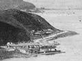
Although flying into windy Wellington can be scary, there has never been a fatal crash landing. But in 1959 the newly extended runway was opened with an air show that nearly ended in disaster. The pilot of a Royal Air Force Vickers Vulcan bomber clipped the southern end of the runway. But he managed to right the plane, and landed safely at Manawatū’s Ōhakea airport.
In 1928, relief workers levelled nearby sand dunes to make an airfield. Later the ridge and the airfield became part of Wellington International Airport.
In 1939 a 22-hectare site in Lyall Bay was developed for the centennial exhibition, marking New Zealand’s first 100 years. Later the exhibition was dismantled and the area given over to housing. Today Lyall Bay is known for its beach, a popular surfing spot.
Miramar and Strathmore Park
The first Māori to occupy Te Whanganui-a-Tara (Wellington Harbour) lived on the island of Motukairangi, now Miramar Peninsula. The horseshoe-shaped island enclosed a lagoon known as Te Rotokura or Para. This was renamed Burnham Water by Colonel William Wakefield. In the 1840s it was drained by landowner James Crawford, and later became a racecourse, reputedly New Zealand’s first.
The area was called Watts Peninsula, but Crawford renamed it Miramar – Spanish for ‘behold the sea’. It remained isolated until 1907 when trams arrived, linking Miramar with the city. The highest point on the peninsula, Mt Crawford (163 metres), is occupied by a prison. In recent times, the suburb has become well known as the location of Peter Jackson’s film studios, where The lord of the rings trilogy and King Kong were made.
Strathmore Park, at the southern end of Miramar, grew after the private secondary school Scots College opened in 1919. From the 1930s it was the site of a state housing development.
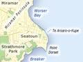
Seatoun and Breaker Bay
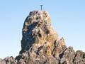
The small seaside settlement of Seatoun is Wellington’s most easterly suburb and one of its most affluent. It stands on a pocket of flat land on the eastern side of Miramar Peninsula. Seatoun beach, Te Tūranganui-o-Kupe, recalls the visit of the Polynesian explorer Kupe, the first person in Māori tradition to visit the harbour. Nearby Steeple Rock is known as Te Ure-o-Kupe (Kupe’s penis) or Te Aroaro-o-Kupe (Kupe’s presence). The inter-island ferry Wahine foundered off Seatoun and sank in 1968, with the loss of 51 lives.
To the south of Seatoun lies Breaker Bay, named for the southerly swells that break on its exposed coastline. Houses – once modest, now increasingly expensive – sit beneath cliffs that lead to the harbour’s southern headland.