Wadestown and Wilton
Clinging to sheer slopes, Wadestown was settled in 1840 as a working-class suburb. But it was also home to one of the city’s richest merchants, William Barnard Rhodes. In the 1920s the Rhodes family subdivided their Highland Park farm, and some of Wellington’s grandest houses were built there.
West of Wadestown is Wilton. Situated in an area Māori called Ōtari, it is named after Job Wilton, who farmed Ōtari in the 19th century. He left an area of his farm in native bush, which now forms the basis of the 100-hectare Ōtari–Wilton’s Bush. It includes a 5-hectare native botanic garden, established by the botanist and schoolteacher Leonard Cockayne in 1926. Wilton developed as a suburb from the 1920s.
Road rage
In the early 1840s, a track up the Ngaio Gorge led to Porirua. As settlement increased, the track was widened to a road. But the Ngāti Toa people, who knew the road would hasten the settlers’ access to their land, harassed the road builders. Governor George Grey responded by building a series of forts to protect the project. One was on Sentry Box Hill (now Box Hill in Khandallah). Others were at Johnson’s Clearing, now Johnsonville, and Glenside.
Crofton Downs, Ngaio and Khandallah
Beyond Wilton, the northern and southern branches of the Kaiwharawhara Stream join to flow down the Ngaio Gorge into the harbour. Crofton Downs lies above the stream’s forks. Settled from the 1960s, it is now the site of the (private) Bowen Hospital, which used to be in Bowen Street, Wellington city.
Ngaio was originally called Crofton, after the home of its most prominent settler, Sir William Fox. It grew after the opening of the Wellington–Manawatū railway in 1885. In the 1920s the Railways Department built a housing settlement in Tarikaka Street, which is now a heritage area.
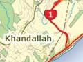
Ngaio’s northern neighbour is Khandallah. An early settler, Captain James Andrew, who had served in the Indian Army, gave the area its Indian name (after Khandela, Rājasthān), and later street names have continued this tradition. With sweeping views across Wellington Harbour, Khandallah became home to the city’s affluent.
Mt Kaukau
Mt Kaukau (445 metres) stands above Ngaio and Khandallah. In 1965 Wellington’s main television transmitter mast was built on its summit, making it the most visible point in the city’s landscape. It was originally known as Tarikākā (meaning ‘where parrots rested’). The name is remembered in the Tarikākā railway settlement in Ngaio.
Johnsonville, Newlands, Paparangi and Churton Park
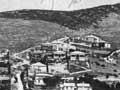
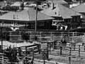
Named after Frank Johnson (an early sawmiller), Johnsonville sits in a small basin and is Wellington city’s northern hub. It began as a small rural service town in the 19th century, growing rapidly after 1938, when a new electric train service linked it to the city.
In the 1960s Wellington’s first shopping mall was built in the suburb. It draws shoppers from the neighbouring communities of Newlands, Paparangi and Churton Park – middle-class suburbs that grew on the surrounding hills from the 1950s. With further subdivisions planned, the district is among the city’s fastest growing.
Tawa, Linden, Glenside and Grenada
North of Johnsonville and on the way to Porirua, these communities straddle the motorway.
Tawa was originally a small farming settlement, subdivided for housing after 1945.
Linden includes a significant area of state housing. Glenside, another farming district, was once known as 'The Halfway', due to its position between Wellington and Porirua.
On the eastern side of the motorway is Grenada, developed in the 1980s. It includes an industrial and warehousing area.