
The Remutaka Range
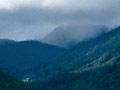
Wellington’s harbour is surrounded by hills. Beyond its eastern shores, the bush-clad ridges of the Remutaka Range dominate the view. Here the southernmost section of the North Island’s mountainous spine meets the sea.
The Remutaka Range extends from the Remutaka Hill Road (north of Upper Hutt) to the harbour’s entrance. Although lower than the Tararua Range to the north, the Remutaka Range is still formidable, with peaks from 700 to 940 metres.
The Orongorongos
This is the popular name for the southern section of the Remutaka Range, including the peak Orongorongo (816 metres).
Fault lines
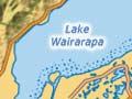
This rugged country is scarred by slips, caused by the massive 1855 earthquake that lifted the range by 3 metres. Estimated to have a magnitude of least 8, it was the most recent upthrust of the West Wairarapa Fault, which lies east of the Remutaka Range. It is the most active fault in the region.
Rivers
Two rivers, the Orongorongo and the Wainuiomata, drain the Remutaka Range, following older fault lines that run parallel with the West Wairarapa Fault.
Huts in the hills
Today the Orongorongo riverbed can be reached via Five Mile Track or from the south coast. In the 1930s, people began building huts in the valley, using four wheel drive access up the river. By 1975 there were 74 dwellings. There is also a research station for studying possums and their effect on the environment.
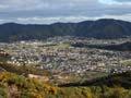
Wainuiomata
Wainuiomata occupies a basin at the headwaters of the Wainuiomata River, between the eastern Hutt hills and the Orongorongos. There is little evidence of Māori occupation of the area before 1840, probably because it was covered in dense forest and large swamps.
The 1855 earthquake raised these swamps and encouraged European settlement. Wainuiomata remained a small sawmilling and farming community until after the Second World War, when new housing soon transformed it into a working-class suburb of Lower Hutt. During the 1950s many young families lived there, earning it the nickname ‘Nappy Valley’. Perhaps its most famous son is the former All Black captain Tana Umaga.
Turakirae
From Wainuiomata the road follows the river to the coast where the Remutaka Range abruptly meets the sea. Three prominent headlands – Pencarrow, Baring and Turakirae heads – dominate the exposed, rocky coastline.
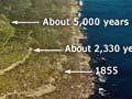
At Turakirae a series of ancient beaches now form terraces well above the present sea level. They were raised from the sea by earthquakes, generated by movement of the West Wairarapa Fault over the past 6,500 years.
Close to Pencarrow Head, 10 kilometres west of Turakirae, two once-tidal inlets have been isolated from the sea by the rising land. They are now the freshwater lakes Kōhangapiripiri and Kōhangatera.
Pencarrow
The Māori name for Pencarrow Head, Te Raeakiaki, means ‘the headland where the sea pounds’. Gravel carried into the harbour by the Orongorongo and Wainuiomata rivers is thrown back onto this coast by southerly storms. As much as 40,000 cubic metres of sand and gravel form there each year. Much of it is removed for building.
The windswept, rocky coastline is a danger to ships entering Wellington Harbour. New Zealand’s first lighthouse was built in 1859 at Pencarrow and operated until 1935. It was replaced by a stronger electric lighthouse on nearby Baring Head.