West of Wellington city, sparsely populated hill country extends from Cook Strait to Mana Island, 30 kilometres to the north. This rugged area has been shaped by streams that dissect an ancient plain.
Guardians of the strait
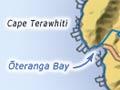
In 1770, after consulting Māori, the British explorer James Cook recorded the name of the south-western tip of the North Island as ‘Teerawitte’ (Terawhiti). The area was important to Māori because of its proximity to Te Moana-a-Raukawa (Cook Strait). From villages at stream mouths on the coast, canoes crossed the strait to trade, or raid. Lookouts on Cape Terawhiti kept watch for the approach of hostile canoes.
European farmers
Cook described the area as ‘exceedingly barren; probably owing to its being so much exposed to the cold southerly winds’. 1 Still, the ‘wild west’ was farmed by early Europeans. From the late 1840s, the main pastoralist was James McMenamen, known as ‘Terawhiti Jack’. His Terawhiti Station still occupies much of the southern section. Further north, in Ōhariu Valley, smaller sheep farms and lifestyle blocks are common.
Seeking gold and pāua
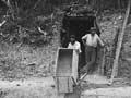
Farming in the 19th century was hard work. More enticing was the lure of gold, first discovered in the region by Māori, in the Waiariki Stream. Prospectors quickly probed the wild west for alluvial gold, with little success. Then quartz-crushing companies followed, with hopeful names such as The Lucky Hit, The Perseverance, and The Hit or Miss. But few prospered from Wellington’s gold rush.
Today, seekers of instant wealth head to the isolated coast at night, to illegally harvest the native pāua shellfish.
Although the area covers about 190 square kilometres it has only 759 residents, most of whom live in Ōhariu Valley and Makara village, or at Makara Beach – the only coastal settlement.
A source of power
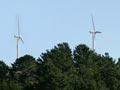
The area plays a part in the national power network because the Cook Strait cable (carrying electricity from the South Island to the North) comes ashore at Ōteranga Bay on the south coast. (This is also where swimmers of Cook Strait depart.) A large wind farm was opened on Makara’s Quartz Hill in 2009, to generate electricity – the first in the region.
Wreck on the rocks
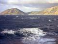
En route from Nelson to Wellington in 1909, the Penguin sank during a southerly storm. The steamer hit Thom’s Rock, near the Karori Stream, forcing all aboard to abandon ship. Seventy-two people died, and some were never found. Four other vessels had already foundered on the ‘demon rock’, which apparently moved about. But there were no more shipwrecks after a lighthouse was built nearby in 1915.
A shipwreck coast
Mariners have always been very wary near this shore. Between 1842 and 1909, 15 vessels were wrecked there.
To the east of Ōteranga Bay, a domed radar station atop Hawkins Hill guides aircraft in and out of Wellington Airport.
Near Wellington’s outlying suburb of Karori, the Makara Hill mountain bike park is an outstanding area for adventurous cycling.