

Hutt Central, Woburn and Waterloo
Lower Hutt’s central business district is the site of the original settlement, although few historic buildings remain. The area is dominated by Queensgate Mall, which has overtaken High Street as the main retail precinct. The valley’s best known cultural institution, the Dowse Art Museum, is also situated here.
Henry Petre farmed the Woburn area from the 1840s, naming it after the Duke of Bedford’s Woburn estate. Petre’s farm was taken over by Daniel and Harriet Riddiford after the 1855 earthquake. Their descendants built a substantial home (demolished in 1981) and gradually subdivided the farm. The northern end became an address for the valley’s affluent, while the southern end was used for new railway workshops.
Waterloo takes its name from the famous 1815 battle won by the Duke of Wellington. It has a mixture of state and private housing.
Boulcott and Avalon
Boulcott is named after Almon Boulcott, who farmed the area in the 1840s. When Māori objected to European settlement, a garrison of regular troops were stationed on his farm. Wanting to assert their authority, local Māori attacked the garrison on 16 May 1846, killing six soldiers before being driven off.
Bugler Allen
One casualty of the Māori assault on Boulcott’s farm was the young private William Allen. Seeing an attack was coming, he raised his bugle to sound the alarm. At that moment his right arm was severed by a tomahawk blow. Grasping the bugle in his left hand he tried again, but was struck down and killed. His bravery made him a hero in colonial society.
In the early 20th century the Avalon area was renowned for its market gardens, but these were turned into mainly private housing from the 1930s. Avalon Studios (film and television) and the Wellington office of GNS Science are sited here.
Belmont Regional Park
Sited on hill country between the Hutt Valley and Porirua, Belmont Regional Park has panoramic views and open space for walkers, mountain bikers and horse riders.
Epuni, Naenae, Taitā
Designed to accommodate 20,000 people, these state-housing suburbs were built from the mid-1940s. They featured the latest town planning ideas, such as curving streets, playgrounds, reserves and community centres. The community centres were to be the social hub, but only a minority of residents became regular users. At first, a consumers’ cooperative – in which residents held shares – dominated retailing, but private enterprise eventually performed better, and the co-op closed.
From the 1950s many tenants bought their homes from the state, but there is still a large area of state housing, where some of the valley’s poorest residents live.
Teenage trouble
In the early 1950s the spotlight fell on Lower Hutt when police claimed that adolescents were engaging in underage sex. In 1952, 61 charges were laid by the police. In 1954 this rose to 107. A government committee of enquiry laid the blame on working mothers, Hollywood films and boredom, among other factors. Some thought this response was overblown. A copy of the committee’s report was sent to every New Zealand home before Christmas 1954.
Stokes Valley
Named after the 1840s surveyor Robert Stokes, the valley was milled from 1858 and converted to farmland. In the early 20th century it attracted holidaymakers, some of whom built baches (holiday homes). During the Second World War an American base was built at the foot of the valley. After the war the Lower Hutt City Council developed the area for housing.
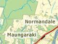
Korokoro, Maungaraki, Normandale and Kelson
Korokoro and Maungaraki were set up by the Liberal government in the early 1900s, under its village settlement scheme. But they remained quite small until the 1960s, when the Lower Hutt City Council developed Maungaraki for private housing. Large earthmoving machinery cut hilltops and filled valleys. It was the largest local government subdivision in New Zealand.
Housing soon spread to the neighbouring hills of Normandale and Kelson.