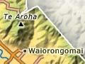
Te Aroha
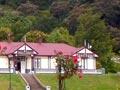
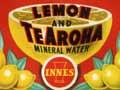
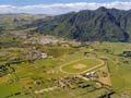
Town 56 km north-east of Hamilton, with a 2013 population of 3,906. Established in the late 1870s, Te Aroha flourished from 1880, when gold was discovered locally. The boom was brief, but hot springs at the foot of the mountain made the settlement prosperous. Te Mōkena Hou, a Ngāti Rāhiri chief, gifted the springs to the government. Te Aroha developed as a spa from 1883, attracting thousands of visitors, especially after a railway link from Hamilton was completed in 1886. Its popularity waned from the 1930s, but some hot pools were modernised in the late 20th century. Visiting Te Aroha domain, with its old bathhouses and formal gardens, is like stepping back in time.
The railway line from Hamilton to the Bay of Plenty via Te Aroha closed in 1978. The town remains the centre of a farming district and industries include animal-skin processing and timber milling.
Te Aroha mountain
At 952 m, the tallest peak in the Kaimai Mamaku Forest Park. The 360-degree views from the summit take in the Auckland, Waikato and Bay of Plenty regions.
One story says the mountain got its name when Tainui ancestress Kahupeka travelled around the Waikato after the death of her husband Uenga. She climbed the peak and named it Te Aroha-o-Kahu (the yearning of Kahu) in memory of him.
Gold was found on the mountain in 1880, and prospectors burned the vegetation in a fruitless search for a reef. At Tui mine, on the northern slopes, lead flux was recovered for gold smelters at nearby Waiorongomai, but the ore contained too much zinc to be useful. The mine reopened in the 1960s, but failed because the ore was contaminated by mercury.
Regenerated vegetation includes rimu, miro and silver beech. A television relay transmitter station and mast were erected below the summit in 1965 and replaced in 1985.
How wrong am I?
After the Waiorongomai gold rush ended in failure for most prospectors, C. W. Richmond wrote this verse:
O wrong are you, o wrong am I
O wrong are all of us
We are all sold, there is no gold
The claim’s not worth a cuss.
We came O why? It’s all my eye
So sing O wai-o-rongo-mai
Here comes the bloomin’ bus
Let’s all get in, it is a sin
The claim’s not worth a cuss.
Singing O wai-o-rongo-mai.
O wrong are all of us.1
Waiorongomai valley
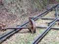
Locality on the southern outskirts of Te Aroha. Gold was discovered there by Hōne Werahiko in 1881, and a settlement grew. Buck’s reef, the main quartz reef containing gold, is one of the largest in the world. However, because the quartz was unexpectedly hard, yields were low. The Piako County Tramway was built in 1882–83 to give access to mines. It had three self-acting inclines, where the loaded wagons going down pulled the empty wagons up. Parts are still intact, making it New Zealand’s oldest railway with rails still in place.
Kaimai Mamaku Forest Park
Forest park covering 37,000 hectares. The Kaimai Range, the central feature of the park, divides Waikato from the Bay of Plenty. Gold mining created a need for timber, and kauri and other tall native trees were also prized for building. Many were felled from the late 19th century.
In the 1960s the Forest Service planned to clearfell areas of the Mamaku State Forest and plant radiata pine. Conservationists protested, petitioning for it to be made a national park. Instead, the Kaimai Mamaku Forest Park was gazetted in 1975. The Forest Service continued to advocate logging, but gradually environmental interests prevailed. In 1987 the Department of Conservation took over management of the park.
Vegetation ranges from dense low-altitude forest to scrub and grassland, and includes kāmahi, red beech and silver beech at their northern limit, and kauri at its southern limit. As well as many bird species, there are small populations of the rare Hochstetter’s frog and threatened Te Aroha stag beetle.
Waihou River
River with headwaters in the Mamaku and Pātetere plateaus. The Waihou meanders along the base of the Mamaku and Kaimai ranges, flows through Te Aroha and then north to the Firth of Thames. In the 1870s Josiah Clifton Firth cleared the river 19 kilometres above Te Aroha so he could ship the produce of his Matamata estate to Auckland. From the 1880s boats brought visitors from Auckland up the river to ‘take the waters’ at Te Aroha. The Waihou remained a transport route until the late 1940s, when it became clogged by willows.