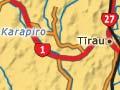


Tīrau
Township 9 km north-west of Putaruru, with a 2013 population of 690. Established in 1870 as a military post, Tīrau became a coach stop for travellers. First called Oxford to identify it as a sister town to Cambridge, it was later named Tīrau to avoid confusion with Oxford in Canterbury. A dairy factory was built in 1938, and a casein factory in 1982.
Tīrau’s transformation
By the late 1980s Tīrau, like many small rural towns, was declining. The post office and a number of businesses had closed. Local entrepreneur Henry Clothier realised that many tourists bound for Rotorua and Taupō passed through Tīrau on State Highway 1. Taking advantage of this, he opened an antique store, turned the old Matamata county council building into an event centre, and encouraged other retailers to open craft stores and restaurants.
From 1908 to 1989 the Matamata County Council had its headquarters there. After 1989, along with the boroughs of Putaruru and Tokoroa, Tīrau was governed by South Waikato District Council. With its many cafés and craft and antique shops, it is a popular stop for travellers on State Highway 1.
Ōkoroire
Locality 6 km north-east of Tīrau. The Ōkoroire hotel was built in 1889 to take advantage of nearby natural hot pools, long valued by Ngāti Raukawa. The tribal ancestor, Raukawa, was born at Ōkoroire. The most attractive is called the Fairy Pool because at night its banks are dotted with glowworms.
East of Ōkoroire, in a reserve off Kākahu Road, is a tōtara niu pole with a carved figure at its base. Dating from around 1845, it was associated with ancient Māori rituals and later the Pai Mārire faith. It was restored in the 1980s.
Fitzgerald Glade
Roadside reserve 6 km south of Tīrau. Driving along State Highway 5 to Rotorua travellers pass through a green oasis – Tukorehe Scenic Reserve, also known as Fitzgerald Glade. Lush tree ferns line the road, and vegetation towering above includes tawa, rimu, mataī and five species of rātā.
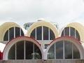
Putaruru
Town 64 km south-east from Hamilton, with a 2013 population of 3,777. The Pātetere block, including the future site of Putaruru, was bought by the Patetere Land Company in the early 1880s, later passing to the Thames Valley Land Company. A settlement emerged about 1886 when the railway line to Rotorua was being constructed. In 1905, after the Crown had acquired surrounding land, a township was surveyed. The Taupo Totara Timber Company built a tramway from its Taupō forests to Putaruru, where it had a mill. Construction of the Arapuni dam on the Waikato River in the 1920s further boosted Putaruru’s population. By 1946 it had 1,160 people and the following year it became a borough.
In the late 1940s the newly established Putaruru Timber Yards built several mills to process wood from exotic forests which had been planted nearby in the 1920s. The mills were taken over by New Zealand Forest Products in the 1970s, but changes in the industry in the 1980s caused Putaruru’s population to decline. In 2008 Carter Holt Harvey, the major timber company at the time, closed its mill.
Water from Te Waihou springs, which feed the Waihou River, is bottled commercially. The town also has a boutique cheesemaker and a cheese school. The Putaruru Timber Museum is situated south of the town. The unusual circular building in central Putaruru, built in 1969, was originally the post office.
Arapuni
Settlement 14 km west of Putaruru. Arapuni, the second hydroelectric dam on the Waikato River, and much bigger than Horahora further downstream, was opened in 1929. A walkway between the dam and the hydro lake, which is popular for fishing and watersports, includes a 152-m swingbridge used by dam workers. The walkway is part of the Waikato River Trail, a network of walkways.
Lichfield
Farming locality 7 km south-east of Putaruru. In the 1880s Lichfield, the base for the Thames Valley Land Company, was larger than Putaruru. It was also a coach stop until the railway to Rotorua was complete. Relics of the 1880s include a brick water tower and a small store building made of Putaruru rhyolite stone. Lichfield was surveyed in 1905 – at the same time as Putaruru – but, like other South Waikato farming settlements, failed to prosper because cobalt deficiency in the soil caused a stock illness called ‘bush sickness’. In the 1930s it was discovered that cobaltised superphosphate could correct this problem. The largest cheese factory in the southern hemisphere is situated at Lichfield.