


Te Awamutu
Town 29 km south of Hamilton with a 2013 population of 10,302. It was originally the site of two important pā: Ōtāwhao and Kaipaka. The town grew on the site of Ōtāwhao mission station, established by the Church Missionary Society in 1841. During the Waikato war the mission became headquarters for British troops, and three redoubts were built. In 1864, 4,000 troops were based at Te Awamutu.
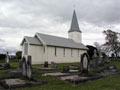
St John’s Anglican church was built for the mission in 1854. Soldiers killed at the battle of Ōrākau are buried in the churchyard, which contains memorials to both British and Māori combatants. The Te Awamutu District Museum has the best collection of Waikato war artefacts in New Zealand.
Members of the Second Waikato Militia settled in the area, but after British troops left and the militia was disbanded in 1867, the town stagnated. It revived only when the railway line arrived in 1880.
From the 1880s Te Awamutu developed as a farming centre, with large saleyards. The first cooperative commercial dairy factory in the North Island opened there in November 1882, followed by others. In the 2010s the town had a Fonterra dairy factory and two major grain factories.
Te Awamutu became a borough in 1915. It is called ‘Rose Town’ because of its rose gardens, which were established in the 1960s.
Ōhaupō
Township 12 km north of Te Awamutu, with a 2013 population of 519. Like nearby Ngāhinapōuri, Te Rore and Harapēpē, Ōhaupō was a military post during the Waikato war. It was settled by Bohemian militiamen connected with Pūhoi settlement north of Auckland, and some of their descendants still live there. A redoubt, built in April 1864, was located about 1 km further north.
Peat lakes
The brown colour of peat lakes is caused by tannin in the surrounding peatlands. Peat lakes in the vicinity of Te Awamutu were formed when the Waikato River changed its course around 19,000 years ago. Water-borne silt and gravel blocked the mouths of valleys, allowing water to build up in the peatlands of the Waikato basin.
Lake Ngāroto
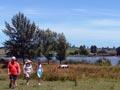
One of Waikato’s largest peat lakes, north-west of Te Awamutu. It is used for yachting, rowing and kayaking, and a walking track has been developed around it. Native vegetation has been planted around the lake to improve the quality of the water, which has high levels of nutrients, sediment and algae caused by runoff from surrounding farms.
Rangiaowhia
Locality 8 km east of Te Awamutu. During the 1840s and 1950s people of Ngāti Hinetū and Ngāti Apakura, with local Anglican and Catholic missionaries, cultivated wheat, maize and potatoes at Rangiaowhia. Little remains now except the historic St Paul’s Anglican church, built in 1856. During the Waikato war Rangiaowhia was the supply base for Māori fighters. On 21 February 1864 British and colonial troops attacked Māori non-combatants taking shelter there, killing some of them.
Pirongia mountain
The tallest mountain (959 m) in Waikato. It was named Te Pirongia-o-te-Aroaro-o-Kahu (the scented pathway of Kahu) by Tainui ancestress Kahupeka. Following European settlement, low-lying forest was cleared, but Pirongia remained untouched. In 1971 it became a forest park.
A farm walkway
The Karamū Walkway, which starts at State Highway 23 between Raglan and Hamilton, passes through the Four Brothers and Karamū scenic reserves, and close to the Kāniwhaniwha Scenic Reserve. However, most of its course is through private farmland, and for that reason it is closed during the lambing season in August and September.
Pirongia mountain has one of the region’s largest areas of forest, with rimu and tawa on lower slopes, and kāmahi, horopito, mountain flax, coprosmas and ferns higher up. New Zealand’s tallest recorded kahikatea tree grows there. It is also home to the rare wood rose (Dactylanthus taylorii), New Zealand’s only completely parasitic flowering plant, which has no leaves and grows partially underground. Tracks lead to the limestone Kāniwhaniwha caves.
Pirongia
Township 13 km north-west of Te Awamutu. First named Alexandra, it was a military post during the Waikato war. In 1864 the Second Waikato Militia built and occupied the Alexandra East and West redoubts, part of a chain of fortifications between Alexandra and Cambridge designed to block possible attack from Māori living south of the Pūniu River. The earthworks of an Armed Constabulary redoubt built in 1872 are well preserved.
In the 1870s Alexandra was the terminus for steamers travelling up the Waipā River. Despite vigorous lobbying by Alexandra residents, the main trunk railway line was constructed through Te Awamutu. This, and reduced river traffic, led to Alexandra’s decline. In 1896 the name was changed to Pirongia to avoid confusion with the Central Otago town.