Hūnua Ranges
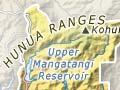
Steep ranges (rising to 688 m) north of the highway between Mangatāwhiri and Miranda, formed of uplifted blocks of greywacke. They are covered with dense forest and much of the area is now a regional park. It was a refuge for Māori when British troops invaded the Waikato in 1863. Since the 1950s the catchments of the Mangatāwhiri River and the Mangatangi Stream, both tributaries of the Waikato River, have been dammed, making the area a major water catchment for Auckland city.
Maramarua
Farming locality on State Highway 2, 21 km east of Pōkeno. The nearby exotic forest was planted in the 1920s and 1930s by relief workers. During the Second World War there was a conscientious objectors’ detention camp there. Detainees felled trees, and commercial logging began in 1951.
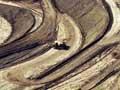
Kōpaku coalfield
Major coal seam near Maramarua. Mining started in the 1800s. In 1947 an opencast mine opened, supplying coal to Meremere thermal power station by an overhead cableway from 1958. When the station closed in 1991 the mine was abandoned. In 2008 Solid Energy announced it would reopen, but it remained closed in 2015.
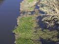
Whangamarino Wetland
Second-largest wetland in the North Island, covering 7,290 hectares between Meremere and Te Kauwhata. The Whangamarino Wetland encompasses peat bog, swampland and river systems. The dominant vegetation is mānuka and wire rush, with moss and lichen species. Threatened plants include water milfoil, the swamp helmet orchid (Anzybas carsei), and clubmoss.
Threatened bird species, including the grey teal, the spotless crake, the North Island fernbird and around 25% of New Zealand’s population of Australasian bitterns live in the wetland. Eighteen species of fish include the black mudfish.
In 1961 the lower Waikato–Waipā flood protection scheme caused water levels to drop by more than 1.5 metres. As part of wetland restoration, a weir was constructed on the Whangamarino River in 1989 to maintain minimum water levels. The Department of Conservation controls animal and plant pests, which include the highly invasive alligator weed.
Hapūakohe Range
Mountain range dividing the Waikato basin from the Hauraki Plains. A walkway along its length offers breathtaking views on both sides.
Te Kauwhata
Town 19 km north of Huntly, with a 2013 population of 1,473. From the 1860s farming began in the Waerenga district to the east. The settlement of Te Kauwhata, originally known as Wairangi, grew around a railway station built in the late 1870s. In 1886 trial plantings of exotic trees began nearby, and in 1892 a government research station started. As Te Kauwhata Viticultural Research Station, it carried out horticultural research, focusing on viticulture, until 1992. Vineyards, including Cook’s Landing and Rongopai Wines, were established locally. North of Te Kauwhata is the Hampton Downs motor racing venue.
Lake Waikare
Waikato’s largest lake, south-east of Te Kauwhata, covering 3,442 hectares and discharging into the Whangamarino Wetland. Its level was lowered for flood control purposes, seriously damaging the natural hydrology. Agricultural runoff, vegetation clearance and pest fish have caused poor water quality. Part of the lake is a wildlife reserve.
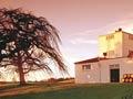
Travellers’ rest
After European settlement, Rangiriri became a coach stop on the road south from Auckland. The historic Rangiriri tavern, built in 1904, replaced an earlier hotel for travellers. Some motorists still take a refreshment break at Rangiriri, but most drive on by.
Rangiriri
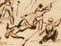
Locality 4 km south of Te Kauwhata. One of the fiercest battles of the Waikato war was fought at Rangiriri on 20 November 1863. The pā built there by Māori to block the British advance was exceptionally strong, and attacking British forces lost many men. Māori defenders, who also suffered heavy losses, surrendered by mistake the following day, under the false impression that a white flag flying from a gunboat meant that the British wanted to negotiate. Part of the pā is now a historic reserve. Some of the British dead are buried in a nearby cemetery. Te Wheoro’s Redoubt – named after its commander, pro-government Māori chief Wiremu Te Wheoro – was built as a British military supply depot after the battle.