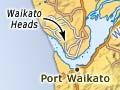


Waikato Heads
Headlands at the mouth of the Waikato River, 40 km south-east of the Manukau Harbour entrance. Huge sand dunes cap both heads, and the river estuary is tidal. At Maioro, on the north head, New Zealand Steel mines ironsand for its Glenbrook mill. Sand combined with water travels to the mill through an 18 km underground pipeline.
Māori brought goods along the river in waka (canoes), which they portaged (carried) overland to the Waiuku River and into the Manukau Harbour. Later commercial shipping to and from Waikato passed through the heads, but shifting sandbars halted this in 1955.
Whitebaiting takes place between the heads and Tūākau.
Old man river
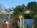
Steel hulks on the banks of the Waikato River south of Mercer are relics of the shipping ventures of Caesar Roose, a lifelong promoter of river transport. For decades until 1976, the steamers, launches and barges of the Roose Shipping Company carried passengers and freight along the Waikato and Waipā rivers. Roose also encouraged shipping trade through Port Waikato, and his company helped build bridges over the Waikato River, including the Caesar Roose Bridge at Mercer.
Port Waikato
Settlement, first called Putataka, on the southern shore of Waikato Heads, 32 km south-west of Tūākau. In 1839 the Church Missionary Society established a mission station and school there. During the Waikato war of 1863–64 a dockyard serviced British gunboats carrying supplies and troops along the river.
Port Waikato expands in summer with crowds of surfers. Striking limestone outcrops in the hills about 8 km to the south were the setting for Weathertop Hollow in the Lord of therings film trilogy.
Te Kohanga
Farming locality on the south bank of the Waikato River, 14 km north-east of Port Waikato. In 1853–54, the Church Missionary Society mission school at Port Waikato shifted here to land given by Ngāti Tīpā chief Waata Kūkūtai.
Tūākau
Town with a 2013 population of 4,182, on the north bank of the Waikato River, 9 km south-east of Pukekohe. Tūākau was originally a trading centre for passing waka, but after war broke out in 1863 it was occupied by British troops. They built the Alexandra Redoubt, the outline of which is still visible, on a tall bluff above the river. After the confiscation of surrounding Māori land, Tūākau became a farming service centre.
Onewhero and Pukekawa
After the Tūākau bridge was opened in 1902, Pākehā began farming around the Māori settlements at Onewhero and Pukekawa, 9 and 14 km south of Tūākau across the river. Radiata pine forests were planted in this rugged area in the 1960s and dairying gave way to beef farming. Lifestyle blocks are now common.
In 1970 the bodies of Pukekawa farming couple Jeanette and Harvey Crewe were found in the Waikato River. Following a controversial police investigation, local farmer Arthur Allan Thomas was found guilty of shooting them. He spent nine years in jail, but was pardoned after a commission of inquiry. The true story behind the murders remains a mystery.
Waikāretu
Locality 49 km south-west of Tūākau, famed for the 1-km-long Nīkau Cave, which features limestone pillars, stalactites and stalagmites.
Pōkeno
Township between the Waikato River and the southern foot of the Bombay Hills, 4 km north-west of Mercer. Originally a Māori village, it became the terminus of the Great South Road, built from Drury in 1862–63. The huge Queen’s Redoubt was constructed as the launching point for the government invasion of Waikato, which began on 12 July 1863 when troops crossed the Mangatāwhiri River 3 km to the south. The redoubt remains are in present-day Pōkeno, which stands near the junction of state highways 1 and 2, and the start of the Waikato Expressway.
The squalid tea of Mercer
Until 1958 Mercer railway station had refreshment rooms where passengers could purchase and hastily consume pies, sandwiches, cakes and cups of tea served in thick china cups. Poet A. R. D. Fairburn wittily commented on this fare in ‘Note on NZR’:
‘The thought occurs to those who are entrained:
The squalid tea of Mercer is not strained.’1
Mercer
Settlement on the east bank of the Waikato River, 34 km north-west of Huntly. Named after a British officer mortally wounded at the battle of Rangiriri in 1863, Mercer became a transport hub. In 1875 the railway from Auckland reached Mercer, shortening the two-day journey to Hamilton. People could travel by train instead of coach to Mercer, and then board a riverboat. The Auckland–Mercer section of the railway later became part of the North Island main trunk line. A walkway along the Koheroa ridge to the east traverses 1860s military sites.
Meremere
Settlement on the east bank of the Waikato River, 30 km north-west of Huntly. A formidable pā on the hill at Meremere was bypassed when gunboats towing barges loaded with British troops steamed upriver before daylight on 31 October 1863. The British then built a redoubt, the earthworks of which are still visible.
Between 1958 and 1991 a coal-burning thermal power station operated at Meremere, and the associated workers’ village remains. To the south, a drag-car racing strip opened in 1973 and, more controversially, Spring Hill prison was built in 2007.