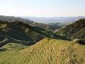
Ranges and hills
The King Country is a broad expanse of uplifted sedimentary rock west of the North Island main divide and central volcanic zone. An area of steep, rolling hills and valleys dissected by rivers and streams, it is part of a larger, geologically similar tract of land that includes inland Whanganui and Taranaki. Mountain ranges flank the King Country – the greywacke and argillite Hērangi Range in the west and the greywacke and ignimbrite Rangitoto and Hauhungaroa ranges to the east. The hills are siltstone, sandstone and mudstone.
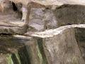
The limestone karst landscape in the centre of the King Country is the region’s most distinctive geological feature. Karst landscapes occur when water dissolves carbonate rocks such as limestone, leaving rocky outcrops, sinkholes, and underground caves laden with stalagmites and stalactites. The region’s pure limestone, hilly terrain and high rainfall created ideal conditions for karst formation.
Describing the land
The Māori settlement of Te Kūititanga – later Te Kūiti – was located near the Mangaokewa gorge. Te Kūititanga meant ‘the narrowing in’ or ‘the closing in’, a reference to the way the hills close in when entering the gorge from the north.
Volcanic landscapes
The most recent changes to land formations in the King Country were caused by volcanic activity. Mt Ruapehu was built up by a series of eruptions over the last 200,000 years and is still active. At 2,797 metres, Ruapehu’s tallest peak is the highest point of the North Island.
Both Mt Ruapehu and its ring plain fall within Tongariro National Park. They lie at the southern end of the Taupō Volcanic Zone, which runs through Lake Taupō and the Rotorua lakes to Whakaari (White Island) off the Bay of Plenty coast. Active faults underlie the volcanic landscape.
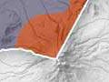
Volcanic activity has had an impact on landscapes some distance from the volcanoes themselves. For example, pyroclastic flows (created when pumice, ash and gas are expelled from volcanoes) travelled from the Taupō Volcanic Zone north to Ōtorohanga and west to Piopio around 700,000 years ago. The flows fused, leaving ignimbrite rock formations.
Lowlands
The region’s characteristic hills give way to rolling, flatter land and alluvial valleys around Ōtorohanga, which is within the Waipā River basin. This basin extends south of Te Kūiti, where the hills become steeper and the valleys narrower. Volcanic activity created the flat plains which form the base of the mountains in Tongariro National Park.
Flood of ’58
In February 1958 the Waipā and Mangapū rivers overflowed and flooded low-lying Ōtorohanga, causing £600,000 (almost $30 million in 2019 terms) worth of damage. Te Kūiti was also flooded, and small townships such as Benneydale and Mangapēhi were temporarily isolated by floodwaters. To prevent further such disasters, the Waipā River was diverted away from Ōtorohanga and stopbanks were built between the river and the town.
Rivers
Rivers and streams cross the length and breadth of the King Country and drain to the north, west and south. The Mōkau River rises in the Rangitoto Range in the east and drains at Mōkau on the west coast. The Waipā River also rises in the Rangitoto Range and flows north into the Waikato region.
The Whanganui River rises on the slopes of Mt Tongariro and travels north-west before turning south at Taumarunui and draining at Whanganui on the west coast. Water from the Whanganui and Whakapapa rivers is diverted to feed the Tokaanu hydro-electric power station. The Ōhura and Ōngarue rivers are major tributaries of the Whanganui River.
Coast
The King Country coastline is bounded in the north by Aotea Harbour, north of Kāwhia Harbour, and in the south by the mouth of the Mōkau River.
Kāwhia Harbour is a large estuary. Originally a valley, it was inundated and then prevented from draining by the formation of a sandbar at the coast. Deeply carved inlets characterise the southern reaches of the harbour.
Large sand dunes are found north of Marokopa, chiefly around Kāwhia and Aotea. The coast between Albatross Point in the north and Mōkau in the south is composed of stratified cliffs formed from sedimentary rock in the Miocene period (23.8 to 5.3 million years ago).
Climate
The King Country has relatively high rainfall compared with regions to its north and east, though similar to that of Taranaki to the south. The inland western side of the region and the volcanoes in the south receive between 2,000 and 4,000 mm each year. The rest of the region receives between 1,500 and 2,000 mm. Westerly winds prevail.
Average annual temperatures are 14–16°C along the coast, 12–14°C in the centre and 10–12°C in the south, south-west and eastern ranges.
The most variable temperatures occur in the volcanic zone – at Whakapapa Village, temperatures can reach 25°C in the summer and fall to -10°C in winter. Southerly winds bring snow in winter.