He kōrero whakarapopoto
The King Country is in the west of the North Island, between Waikato and Taranaki. It is an area of rolling hills and valleys, with limestone landscapes featuring caves and sinkholes. Mt Ruapehu, an active volcano, is the North Island’s highest point. Kāwhia Harbour is a large estuary.
Plants and animals
Much of the King Country was covered in native forest until it was cleared by European settlers. Mts Ruapehu, Ngāuruhoe and Tongariro were gifted to the Crown in 1887, and became Tongariro National Park.
Some rare birds live in Pureora Forest and Whareorino Forest. Fossils can be found on the west coast.
Early Māori history
The Tainui canoe, which brought the ancestors of Māori to New Zealand, landed at Mōkau and was buried at Kāwhia.
The main tribe is Ngāti Maniapoto.
European contact
From the 1820s Māori had contact with Europeans. Mission stations were set up in the 1830s. In the 1850s the government bought blocks of land, but they were not even surveyed until the 1880s.
Te Rohe Pōtae
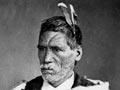
Ngāti Maniapoto supported the King movement, which promoted Māori unity and a Māori monarch. The tribe fought alongside Taranaki and Waikato tribes against the government in 1860 and 1863, and hosted the exiled King Tāwhiao from 1864 to the early 1880s – hence the name ‘King Country’. The area was largely off-limits to Europeans and the government. It became known as ‘Te Rohe Pōtae’ (the area of the hat), supposedly because the king put his hat down on a map to show where the boundaries were.
In 1882 Ngāti Maniapoto agreed to their lands being surveyed to prepare for the main trunk railway line. The government used the railway to open up the area to European settlement.
Population and society
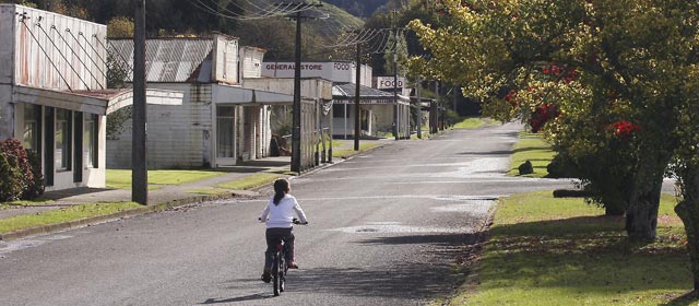
The King Country was settled by Europeans later than most other parts of New Zealand. The population grew in the early 20th century, but growth slowed in the 1930s and the population fell from the 1960s.
Industry
Sheep, beef and dairy farms were established, but problems with soil fertility and ‘bush sickness’ (a wasting disease in animals caused by cobalt deficiency) led to some farmers abandoning their land. After cobalt was added to fertiliser, bush sickness was no longer a problem.
As the forests were cleared sawmills were set up. Exotic forests were planted in the 20th century.
Coal was mined in some areas, but all the mines later closed.
Politics
In the 2000s the area was covered by the Taranaki–King Country electorate. National Party members have represented the district in Parliament since 1936. The King Country is part of Te Tai Hauāuru Māori electorate.
Tourism and sport
The Waitomo Caves were run as a tourist attraction by the government from the early 1900s. New Zealand’s first ski club was started at Mt Ruapehu in 1913. Tourists also went on cruises on the Mōkau River, and down the Whanganui River from Taumarunui.
Rugby and sheep-shearing are notable sports.
Culture and heritage
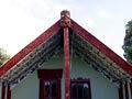
Writers associated with the King Country include Pei Te Hurinui Jones, F. L. Phillips and Frank Sargeson. Artist Peter McIntyre had a holiday house at Kākahi; Rangimārie Hetet was a distinguished Māori weaver.