


Significant European settlement of the King Country happened much later than in most other parts of New Zealand. It was one of the least accessible parts of the North Island, and had few settlers before it was closed to Europeans in the 1860s. The opening of the Rohe Pōtae 20 years later made European settlement possible on a much larger scale than previously.
Population report
In the 1880s government surveyor Lawrence Cussen tried to estimate the Māori population of Te Rohe Pōtae. He found this difficult because, as he wrote, ‘natives travel about so much – attending meetings, Native Land Court etc …’1 Cussen noted that many of the younger people left their homes to build railway lines and roads, and dig kauri gum in Hauraki.
19th century
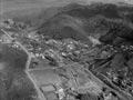
European settlement proceeded slowly after Te Rohe Pōtae was opened because most Māori were reluctant to sell land to the government, and because construction of the railway line south of Te Kūiti was slow. The European population grew from 362 in 1886 to 427 in 1891 and 754 in 1896. Including Māori (who were recorded by a somewhat unreliable separate census), the region’s population was around 3,200 in 1896.
New growth
The total population grew more rapidly in the early 20th century, from 5,475 in 1901 to 27,086 in 1926. During this period more land was made available for European settlement and the main trunk railway line was completed.
Slower growth
In the 1920s soil erosion became a problem and land that was difficult to farm was abandoned in some areas. Prices for pastoral products were sluggish, and fell sharply in the early 1930s. While the population continued to grow – to 31,411 in 1936 – the rate of increase slowed markedly. A 4% drop between 1936 and 1945 was offset by renewed growth (mostly in the towns) after the Second World War. By 1961 the region’s population was 38,916.
Decline
The population declined thereafter. It dropped by one-third between 1961 and 2013, when it was 25,938. Like other rural areas, the King Country was affected by periods of falling wool prices and weakening meat prices, and by out-migration.
Pine planting in Pureora State Forest stopped in the 1950s and coal mines and sawmills closed in the succeeding decades. The region did not have a strong enough manufacturing base to offset weakening primary-sector industries and related population decline. Developments in farm technology meant less labour was needed. Because the region had relatively small towns and no cities, population-based government spending was limited.
Ethnicity
The European population probably overtook the Māori population by 1906. Just over a century later, in 2013, 71.6% of the King Country population identified as European – slightly lower than the national figure of 74%. Māori made up 36.4%, more than double the national figure of 14.9%. Pacific people comprised 2.9% and Asian people 2.3% of the regional population.
Dry area
In 1884 the government made the King Country a ‘dry’ area at the request of Ngāti Maniapoto leaders. This meant liquor could not be legally sold. The people were by no means teetotallers – sly-grogging (illegal liquor manufacturing for sale) was widespread and drinkers pooled money to bring in liquor for personal use from outside the dry area (which was legal). Chartered clubs could obtain liquor licences from 1946 and prohibition was lifted in 1954.
Booze smuggling
Alcohol intended for resale was smuggled into the King Country in creative ways. In Ōngarue, local legend tells that special containers were made to fit inside horse collars that were sent to Auckland by train for ‘repair’. The collars were returned with the containers filled with whisky – and the police were none the wiser.
Iwi authority
The Maniapoto Maori Trust Board, formally established by an act of Parliament in 1988, is the King Country’s main iwi authority. The board maintains a roll of tribal beneficiaries whom it represents on matters that affect their welfare.
Other iwi have interests in the King Country. Ngāti Manunui (a hapū of Ngāti Tuwharetoa) has a marae at Kākahi, and hapū of Te Āti Haunui-a-Pāpārangi (a Whanganui iwi) have a number of marae in Taumarunui.
Treaty claims
Ngāti Maniapoto and other King Country iwi have filed a series of claims with the Waitangi Tribunal. These were grouped together as the Te Rohe Pōtae District Inquiry, which was in its final phase in 2015.