

Landscape
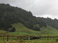
The King Country is located in the North Island’s western uplands. It is flanked by mountain ranges to the west and east, and its landforms are strongly influenced by the active volcanic zone of the central North Island. The lowlands of the northern reaches look towards Waikato, while the steep hill country further south is part of the rugged terrain which characterises the inland Whanganui and Taranaki regions. Much of the forest has been felled, but the remnants – principally on the western, eastern and southern boundaries – recall the region’s ancient name, Te Nehe-nehe-nui (the great forest).
Names
The name ‘King Country’ embodies a relatively brief though crucial period in the region’s history. A name bestowed by Europeans, it recalls the period in the 19th century King Tāwhiao spent in Ngāti Maniapoto territory, exiled from his Waikato homeland. The name ‘Te Rohe Pōtae’, which loosely translates as ‘the area of the hat’ – supposedly referring to an incident in which King Tāwhiao defined the area's boundaries by throwing a hat onto a map – was coined by Māori and asserted Māori sovereignty over the region. Neither are official place names, but they are commonly used labels for the area.
Settlement
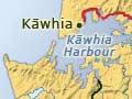
The Tainui waka (canoe), which brought the ancestors of Māori to New Zealand from Polynesia, landed on the west coast at Kāwhia and Mōkau. Maniapoto, the founding ancestor of Ngāti Maniapoto (the main iwi of the King Country), was descended from the captain of Tainui. Kāinga (villages) and fortified pā were established on the west coast and along rivers.
European traders first visited the King Country around the late 1820s. They were followed by missionaries in the 1830s. The region was closed to Europeans for two decades after the Māori king, Tāwhiao, and his followers were exiled to Ngāti Maniapoto territory following the battle of Ōrākau in 1864. It was during this period that the region was first called Te Rohe Pōtae.
Negotiations to open the region to European settlement began in the 1870s. Ngāti Maniapoto agreed to a survey through the Rohe Pōtae for the main trunk railway line in 1882. The railway line, which reached Ōtorohanga and Te Kūiti in 1887 and Taumarunui in 1903, facilitated the opening of the King Country to Pākehā.
The first European settlers took up farms in the early 1890s and settlement spread inland from the west coast. Growth in the European population did not take off until the early 20th century. Town growth was fostered by the railway line. Farming, sawmilling and coal mining were important sources of prosperity.
Boundaries
The King Country comprises Ōtorohanga and Waitomo districts and the northern two-thirds of Ruapehu district. It is not an official region, but a regional identity has developed within these approximate boundaries .