
Māori control
The government did not pursue the Māori king beyond the aukati (boundary), and no land within Ngāti Maniapoto territory was confiscated. These lands were largely off-limits to the government and settlers until the early 1880s. A small number of Europeans who entered the territory unauthorised were expelled or killed.
The King movement existed unchallenged within its central North Island stronghold. Native Minister Donald McLean agreed that Māori fugitives would not be pursued there. The most famous of these was the rebel leader and prophet Te Kooti, who lived at Te Kūiti from 1873 to 1883 and then at Ōtewa (south-east of Ōtorohanga) until 1893.
Contact with the outside world did not cease altogether. Māori traded across the aukati – many moved closer to the northern boundary so they could trade more easily with European towns such as Alexandra (present-day Pirongia). Government officials and envoys made occasional visits.
Hat authority
While the name ‘Te Rohe Pōtae’ is best known as applying to the King Country, it was also used elsewhere to mean autonomous Māori land. ‘Te Rohe Pōtae o Tūhoe’ referred to Tūhoe tribal land beyond a confiscation line in the eastern Bay of Plenty in the late 1860s. Tūranganui (Gisborne) Māori also spoke of the concept in the 1850s. The head is sacred to Māori, and the idea that the ‘pōtae’ (hat) related to authority over land was derived from the crown worn by Queen Victoria – one of the symbols of her authority.
Names
From the 1860s Ngāti Maniapoto territory was called the King Country or ‘the King’s country’ by Europeans. While this described Tāwhiao’s temporary (though lengthy) place of residence, it ignored Ngāti Maniapoto’s position as tangata whenua. It would be more accurate to call Waikato the king’s country.
King Tāwhiao is reputed to have conferred the name Te Rohe Pōtae, loosely translated as ‘the area of the hat’, on the land in the late 1870s when he threw a hat down on a map. Ngāti Maniapoto leader Wahanui Huatere has also sometimes been identified as the person who coined this name. ‘Te Rohe Pōtae’ came to be used by Pākehā as well as Māori. The aukati (boundary) between Waikato and Ngāti Maniapoto was along the Pūniu River.
Diplomacy
In the 1870s the government tried to persuade Waikato and Ngāti Maniapoto leaders to allow European settlement in Te Rohe Pōtae. Premier George Grey and Native Minister John Sheehan both met with King Tāwhiao and Ngāti Maniapoto chiefs with a view to achieving this goal, but their negotiations failed.
Changing opinions
Sheehan nonetheless sensed some interest within Ngāti Maniapoto in opening up their land. The tribe wanted to harness the economic potential of the land and protect their customary interests in case rival claimants applied to have title determined by the Native Land Court. They wanted to lease rather than sell land to settlers. A few Europeans were now permitted to settle in the area – the first was Alexander Bell at Taumarunui in 1874.
King Tāwhiao did not want to negotiate with the government until it guaranteed Māori autonomy over the land. Tactical differences between Ngāti Maniapoto and Tāwhiao saw the government negotiate with Ngāti Maniapoto chiefs alone.
Kāwhia
In 1880 the government gained a toehold when it purchased land at Kāwhia originally bought by a European settler before 1840. From 1882 streets were laid out, buoys fixed in the water and beacons placed on the land. Waikato Māori were at first angered by these developments, which occurred without their knowledge, but accepted them after discussions with Native Minister John Bryce.
The land
The authors of the 1883 petition eloquently expressed the importance of the land above all other considerations: ‘What possible benefit would we derive from roads, railways and Land Courts if they became the means of depriving us of our lands? We can live as we are situated at present, without roads, railways, or Courts, but we cannot live without our lands. We are not oblivious of the advantages to be derived from roads, railways, and other desirable works of the Europeans. We are fully alive to these advantages, but our lands are preferable to them all.’1
1880s negotiations
In 1882 Ngāti Maniapoto agreed to a survey along the proposed route of the main trunk railway line through Te Rohe Pōtae. In return they wanted the government to agree to various proposals. Some of these were made in an 1883 petition by Ngāti Maniapoto, Ngāti Raukawa, Ngāti Tūwharetoa and Whanganui tribes, who banded together to protect their interests in the western hill country. The petition requested that the Native Land Court not operate in Te Rohe Pōtae, that Parliament pass a special law to prevent the land from ever being sold, and that iwi be allowed to fix the boundaries of – and tribal boundaries within – the area. The area described in the petition was about 142,000 hectares.
Outcomes
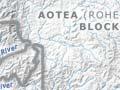
The government did not agree to these requests. Individual claimants began making applications to the Native Land Court and the first court hearing was in 1886. The court then determined boundaries. An ‘official’ Rohe Pōtae (also known as the Aotea block) of 78,000 hectares, belonging to Ngāti Maniapoto alone, was created by the court. The other three iwi and the remaining land were dealt with separately.
Secret sales
Some early land sales by Māori to government agents were conducted in secrecy for fear of incurring tribal leaders’ wrath. In 1890 an agent wrote that ‘the two who just disposed of their interests … were fully a fortnight after discussing the matter with me, before they could screw up their courage to sell, and, instead of coming to me in the day time they waited upon me at 9 p.m … having ridden 12 miles since sundown … and returned that night least any of the local natives should see them and surmise that they had been selling land.’2
The court subdivided the Aotea block from 1888. The government had sole purchasing rights and government agents started buying individual land shares in 1890.
Some agreements were reached. At Ngāti Maniapoto’s request the region was made ‘dry’ – the sale of liquor was prohibited. Māori fugitives – including Te Kooti – sheltering within Te Rohe Pōtae were pardoned in 1882.