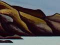
Waitākere Ranges
Rugged forested range of hills (reaching 450 m), stretching north-west from the north head of the Manukau Harbour. The Waitākere Ranges were an important stronghold of the Kawerau people. The region takes the name Waitākere, meaning ‘wave-swept rock’, from a small bay at the northern end of Te Henga. Annual rainfall is 2,000 mm – compared with 1,268 in central Auckland.
Felling frenzy
Between 1840 and 1940, 23 timber mills worked the Waitākere Ranges. They took 300 million superfeet (708,000 cubic metres) of kauri timber – about 120,000 trees. By the 1920s there was little kauri forest left in the Waitākeres. In the 1940s what remained was protected in reserves.
Timber mill to regional park
From 1859 to 1925 mill owners carried out indiscriminate logging of the dense kauri forest. In the 20th century the Waitākere area became a major water catchment area for Auckland, with the first small dam built in 1902. From 1894 sections of forest were reserved for the public. A major expansion came in 1940 when 6,400 hectares of the Waitākeres were made the Centennial Memorial Park, marking the centenary of Auckland’s founding. Today the Waitākere Ranges Regional Park includes 16,000 hectares and 143 walking tracks. The most spectacular remaining kauri, 1,500–2,000 years old, can be seen in the Cascades Kauri Park.
West Coast beaches
Chain of wild beaches along the west coast of the Waitākere Ranges, extending from Muriwai in the north (45 km from central Auckland) to Whatipu at the mouth of the Manukau Harbour. They have pounding surf from the Tasman Ocean, rugged cliffs and black ironsands. Many coastal headlands have been pā sites of the Kawerau people.
Muriwai
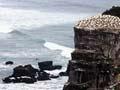
Also known as One Rangatira (‘the chiefly beach’), this settlement stretches north of Te Henga. Its toheroa (shellfish) have been sought-after for generations (although collecting them is now prohibited). One million people a year visit the gannet colony beside Motutara area, which became Muriwai Regional Park in 1969. Woodhill Forest (12,500 ha), planted with pines on sandy dunes behind Muriwai in 1934, is popular for hunting, horse-riding and motocross.
Te Henga to Whatipu
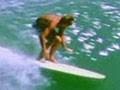
The Waitākere River opens out at Te Henga (Bethells Beach), the focus of Kawerau settlement in this area. Further south is Piha and the pā site, Whakaari. Inland are the Kitekite Falls. Piha is famed for its long-established surf club, and Lion Rock. Karekare Beach, south of Piha, is the site of Jane Campion’s 1993 film The piano. Whatipu (44 km from central Auckland) is the southernmost and bleakest of the West Coast beaches, interesting for the sand dunes that have extended from its cliffs.
Huia
Holiday settlement on the northern shore of Manukau Harbour, 32 km from central Auckland. Its name derives from Te Rau o Huia, meaning the plume of the huia bird. Nearby at Little Huia the summit of Mt Donald McLean (390 m) offers spectacular views of the city and the harbour.
Cornwallis
Holiday settlement on the Pūponga peninsula, 31 km from central Auckland. A monument on the highest point of the peninsula commemorates the Scottish settlers who settled there in 1841, but failed to prosper.
Titirangi
Picturesque suburb of houses scattered through the southern Waitākere Range, between Glen Eden and Laingholm. On the fringes of Auckland, for a long time Titirangi had a reputation for bohemianism, and it is still home to many artists. From Titirangi township the Scenic Drive traces the eastern ridge of the ranges for 50 km. The Arataki Visitors’ Centre, 6 km away, showcases Te Kawerau-a-Maki sculpture and life in the west.