
Cape Rodney–Ōkakari Point Marine Reserve
This is New Zealand’s first marine reserve (popularly called Goat Island Marine Reserve), and the site of the University of Auckland’s marine research laboratory. The reserve lies along a 5-km stretch of coastline north of Leigh and extends 800 m offshore. It attracts 100,000 visitors a year.
Wakatuwhenua (Goat Island Bay) was the landing place of the Moekākara canoe, commanded by Tāhuhunui-o-te-rangi.
Leigh
2013 population: 441
Holiday settlement and deep-water fishing harbour south of Cape Rodney, 21 km north-east of Warkworth. Traditionally known as Ōmaha Cove, the site was renamed after the Wesleyan missionary Samuel Leigh. Today, Leigh Fisheries airfreights snapper, tuna and lobster overseas and employs one in five of the local population.
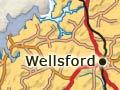
Warkworth
2013 population: 3,909
Picturesque township 69 km north of Auckland and 15 km up the Mahurangi River, beside Puhinui Falls. Many pā sites remain along the coastal headlands. In 1843 the settler John Anderson Brown purchased the area, naming it after his Northumberland birthplace.
Industry
In the 19th century, shipbuilding flourished with the ready supply of timber from the kauri forests. Early settlers also developed orchards on land too poor for crops. The Red Bluff Orchard, established by Edward Morrison in 1873, was one of New Zealand’s largest orchards by 1914, with 250,000 trees. Another important industry was Nathaniel Wilson’s Cement Works, the first in Australasia to produce Portland cement (the most common type).
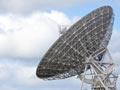
During the 20th century, orchards made way for dairy and sheep farms. New Zealand’s main satellite communications station was constructed 5 kilometres south of Warkworth in 1971. As coastal land values have soared, farms have been redeveloped as wealthy housing estates, or replaced by vineyards, deer and ostrich farms.
Kawau Island
2013 population: 78
Island 8 km east of the Rodney coastline. It was named Te kawau tū mārō (‘the shag that stands sentinel’), because of the number of shags that flocked to its pōhutukawa trees. Before the 1820s the shark-fishing grounds made Kawau home for generations of Kawerau and Marutūahu sub-tribes. Momona Pā remains the most visible of 13 headland pā.
Copper mining
Families from Cornwall and Wales formed a mining community on the island after deposits of copper and manganese were discovered in the 1830s and 1840s. Around 3,000 tonnes of copper were extracted before the mine was abandoned in 1855.
Island retreat
In 1862 Governor Sir George Grey bought Kawau and built a large home there. After Grey sold the estate in 1888, the mansion became a boarding house and stopover for yachties en route to Great Barrier and the north. Broken bottles in the bay were said to form a ‘sediment a fathom deep’. 1
Trouble in paradise
Governor Sir George Grey wanted to make Kawau an island haven. He imported exotic plants and a variety of animals, especially sporting prey. But not all thrived. The sea was too warm for the trout, the zebras met violent deaths, and Grey shot the monkeys because they made a raucous noise in the trees around his house.
Restoration
For over 100 years the island has been popular with tourists. In 1977 the Mansion House and gardens were purchased by the Hauraki Gulf Maritime Park, and in 1979 the house was restored and reopened for the public. The island is administered by the Department of Conservation.