
History
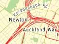
The CBD was part of a central wedge of the isthmus that was the first land bought from Ngāti Whātua by the Crown in 1840. It covers 433 hectares in a triangular area bounded by the Waitematā Harbour and the inner suburbs of Ponsonby, Newton and Parnell.
The city’s commerce first developed around Shortland Street above Commercial Bay, close to the site where Captain Hobson founded Auckland on 18 September 1840. Princes Street became the seat of government and the site of some fine merchant homes. Queen Street, with its banks, shops and warehouses, was built over the Horotiu Stream and soon became the heart of the CBD. The role of Māori in the founding of Auckland is celebrated in Molly McAllister’s statue of a warrior at the foot of Queen Street.
The CBD gradually declined after 1960. Factories moved from the inner city to cheaper land in west and south Auckland, and suburban shopping malls brought the closure of downtown department stores. The CBD remained a stronghold of financial and service industries. This was reinforced in the 1980s, when Auckland replaced Wellington as New Zealand’s financial capital, and new high-rise office buildings reshaped its skyline.
Renewal and controversy
During the 1990s education became the CBD’s biggest export earner. As well as the University of Auckland and Auckland University of Technology, new schools catered for large numbers of Asian students of English. The inner city was revitalised by these and others drawn to apartment life. Clubs and cafés reinvigorated the former red-light areas near Queen Street and along Karangahape Road.
Between 1991 and 2013 the population grew from 1,400 residents to over 32,400. Of these, 45% were of Asian origin and the median age was 26.9 years (compared with 31.5 years for Auckland as a whole). An important project was the Britomart transport centre, opened in 2003 to coordinate train, ferry and bus transport. The aim was to reduce traffic in a city where 60% of people entering the CBD on weekdays were travelling by car. Queen Street has remained the gathering point for festive parades and protest marches.
Since 2006 public concern over shoddy commercial developments and the government’s advocacy of a massive, port-side stadium has led to a review of the design of the CBD.
Straight up
Building Auckland’s Sky Tower required sophisticated technology to ensure it was dead straight. Measurements were taken from three surrounding points: the ASB Bank building, Mt Eden, and the Coopers and Lybrand building. Lasers were used to get verticality readings, and seven satellites fixed its exact position.
City icons
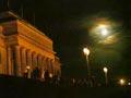
The Auckland War Memorial Museum, Tāmaki Paenga Hira, is New Zealand’s largest neo-classical structure. It is sited on Pukekawa Hill (‘hill of bitter memories’), the highest point in the expansive grounds of the Auckland Domain. The 81-ha Domain, Auckland’s first park, was established in 1845. The expanse of lawns and trees links the CBD with the eastern suburbs. Auckland Art Gallery, Toi o Tāmaki, designed in French Chateau style, was the first permanent gallery in New Zealand (1887) and is the largest today.
Distinctive new buildings include the Sky Tower, which dominates the skyline, and the arc-shaped Business School at the University of Auckland.