Papakura
Town on the shores of the Pahurehure inlet of the Manukau harbour, 34 km south of Auckland city. An early frontier settlement, Papakura retained its independence as a separate district from the surrounding Franklin County. Papakura marks the southern suburban fringe of greater Auckland and the gateway to the rural south.
Military camp
The Papakura Military Camp was established on the outskirts of the town in 1939, and remains an important army base (though it was closed from 1992 to 2002). In the early 2000s some land was set aside for new housing development, including state housing.
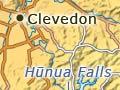
Clevedon
Rural centre on the west bank of the Wairoa River, 40 km south-east of central Auckland. Its traditional name was Te Wairoa. Whitford to the north, with its 10-acre lifestyle blocks, has become a rural retreat for wealthy commuters.
Traditional bach (holiday-home) settlements along the south coast of Tāmaki Strait from Maraetai to Beachlands have grown into commuter suburbs.
Hūnua Ranges
Steep ranges (rising to 688 m) south-east of Papakura, stretching to the Firth of Thames. The ranges are formed of uplifted blocks of greywacke, and covered with dense forest. The area was a refuge for Māori when British troops invaded the Waikato in 1863. Since the 1950s, some valleys have been dammed, making the area a major water catchment for Auckland.
The Hūnua Falls on the Wairoa River have been a favourite tourist spot since the 19th century. Hūnua Ranges Regional Park (17,000 hectares), lying astride the Auckland–Waikato boundary, is a huge recreational area and protects regenerating kauri.
Drury
Small township 5 km south of Papakura, named after Captain Drury, who surveyed Manukau Harbour. When the Great South Road was built from Auckland to the Waikato River in the early 1860s, Drury became a base for British military operations against Waikato Māori. Today it is a major area for glasshouse horticulture.
Culture clash
The Bombay hills form a symbolic border between Auckland and the rest of the nation. People south of the hills mock Aucklanders’ brashness and self-importance, whereas those to the north lampoon southerners’ plainness and conformity. On either side of ‘the frontier’ you may hear the phrase ‘New Zealand stops at the Bombay hills’.
Bombay
Settlement 10 km south-east of Drury, on an eroded volcano which formed the steep Bombay hills. It is named after a ship that brought English migrants to clear and farm the district in 1863. In the early 1900s an Indian community settled in the area; a Sikh temple, opened in 2004, is prominent at the town’s entrance.