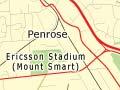


Glen Innes, Pt England and Tāmaki
Low-income suburbs lining the west bank of the Tāmaki River. In the 1950s tracts of state housing were constructed southwards from Glen Innes to serve industrial growth in Mt Wellington and Penrose. Their position – close to central Auckland and beside a suburban railway – has encouraged urban renewal and medium-density housing. A campus of the University of Auckland is sited in Tāmaki.
Panmure, Mt Wellington and Ōtāhuhu
Industrial suburbs stretching from the north-east arm of the Manukau to the Panmure Basin. Between Westfield and Ōtāhuhu lies the narrowest point in New Zealand, the 1-km strip between the Tāmaki River and the Manukau that Māori used as a canoe portage.
Industrialisation
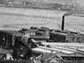
Panmure, Ōtāhuhu and also Onehunga began as military settlements, from which the Pākehā invasion of Waikato was launched in the 1860s. In the early 1900s, cheap flat land and easy access to ports, roads and railways made this an ideal area for heavy industry. Southdown freezing works, opened in 1905, were followed by Westfield and Hellaby’s works, new railway workshops, and rubber, chemical and fertiliser companies.
The works
Tracey McIntosh describes life in Ōtāhuhu before the freezing works closed in the 1980s. ‘I grew up in a street neatly cut in half by the main trunk railway-line, in which nearly all the Maori men (like my Pakeha father) worked at one of the three freezing works … On swimming days I took along my towel with the red and white Westfield insignia, and looked scornfully at those who carried Hellaby or Southdown towels. The works were all dense communities … that extended far beyond the abattoir walls, reaching out to many parts of South Auckland.’ 1
The 1980s changed the landscape and workforce, with the closure of the freezing works and the railway workshops. The area from Te Pāpapa to Ōtāhuhu is now dominated by large warehouses and the New Zealand Forest Products paper mill.
Recent growth
In Penrose, new industrial parks have been built beside the southern motorway. The Auckland City Council’s Tāmaki Edge Urban Renewal Scheme will include a technology park in the former quarry at Mt Wellington, with medium-density housing for predicted growth from Glen Innes to Sylvia Park. It includes the Tamaki transformation project, which focuses on improving housing and socio-economic conditions in Glenn Innes, Point England and Panmure. The Sylvia Park mega-mall, opened in 2006, is New Zealand’s largest.
Onehunga
Suburb on the north-eastern arm of Manukau Harbour. Onehunga thrived during the 19th century as a timber port and a passenger port for travel to the lower North Island and South Island. It still functions as a secondary port. For much of the 20th century it was a strong working-class community, but since the 1990s parts of it have been gentrified.