Rangitoto Island
2013 population (including Motutapu and Rākino islands): 60
Cone-shaped volcanic island in the inner Hauraki Gulf, 4 km north-east of the entrance to the Waitematā Harbour. Rangitoto’s graceful silhouette is a symbol of Auckland. It is the largest and most recent of Auckland’s volcanic cones – the eruption which formed the island, around 1400 AD, was observed by Māori. The island was bought by the Crown in 1854, and quarried before it became a public reserve in 1890.
Motutapu Island
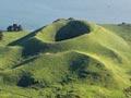
Island 10 km north-east of the entrance to the Waitematā Harbour. It is joined to Rangitoto by a natural causeway, but the landscape of sandstone cliffs and gentle farmland is dramatically different. Footprints and artefacts preserved in solidified lava show that Motutapu’s residents saw Rangitoto’s eruptions. Two forts and hundreds of Māori archaeological sites remain. The Department of Conservation has converted former Second World War barracks into an outdoor education centre.
Rākino Island
Motutapu is separated from the small Rākino Island by the 2-km Rākino Channel. Rākino was bought by Governor George Grey in 1862 and was later owned by Sanford Fisheries who developed their industry from this base. The island was subdivided in 1965.
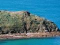
Motukorea Island
Island 2 km from the mouth of Tāmaki estuary. The cone (68 m), deep crater, and associated knolls make the island Auckland’s most intact volcano. Motukorea is also known as Brown’s Island, after William Brown, who purchased it in 1840. It has been farmed continuously since then. In 1955 Sir Ernest Davis donated the island to Auckland city, which co-manages it with the Department of Conservation.
Motuihe Island
Anchor-shaped island 16 km east of Auckland. The clearest signs of centuries of Māori cultivation on Motuihe are evident at Pā Point. Most of the island is covered by rolling farmland, with groves of Norfolk pines. Motuihe served as a quarantine station for 50 years from 1873. During the First World War it became a detention centre for German residents in New Zealand and prisoners from (German) Samoa.
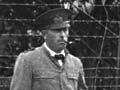
Plucky escape
Count Felix von Luckner, a captain in the German Navy, had sunk 86,000 tons of Allied shipping when he was captured in Fiji in 1917. He was imprisoned on Motuihe. Three weeks later he escaped, taking the commandant’s launch and then commandeering a scow and its crew. After sailing to the Kermadec Islands, he was recaptured.
The station became a children’s health camp in the 1930s and a naval base in the Second World War. In 1963 it was sold to Auckland city, which vested it in the Hauraki Maritime Park Board in 1967. Motuihe’s fine beaches and regular ferry service make it one of the most popular islands in the Hauraki Gulf.
Waiheke Island
2013 population: 8,259
The largest and most urbanised of the inner islands of the Hauraki Gulf, 17 km from Auckland. Before subsidence created the Firth of Thames several million years ago, the island was part of the Coromandel Peninsula, 15 km east.
Many headland pā remain from Waiheke’s long occupation by the Te Arawa and Hauraki tribes. By the 1890s the beaches and balmy climate had made it a favourite resort. In recent years the development of vineyards, cafes and a fast ferry service has increased the island’s popularity and led to soaring property prices.
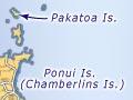
Pōnui Island
Island 1.3 km to the east of Waiheke, farmed continuously by the Chamberlin family since 1853. The island includes a wildlife sanctuary.