Great Barrier Island (Aotea)
2013 population: 927
Island lying 90 km north-east of Auckland. Great Barrier is the largest of the North Island’s nearshore islands: 40 km long and 16 km across. It is the broken-off tip of the volcanic chain that runs up the Coromandel Peninsula, 15 km to the south. Mt Hobson (Hirokimata, 621 m) is the highest point of the island’s rugged hills. On the west coast are five fiord-like harbour entrances, while the eastern side has white sandy beaches.
Early settlement
The island was visited by the ancestral Aotea canoe and occupied by Tainui and Te Arawa sub-tribes. James Cook renamed the island Great Barrier in 1769 because of the protection it gave to the Hauraki Gulf. Remnants of 19th- and early 20th-century industry remain in abandoned mine shafts, whaling stations, dams and mills.
Conservation
Since the New Zealand Forest Service began regenerating the kauri forest in the 1970s, the island has become a stronghold for flora and fauna. There are 500 plant species on the island, 70 different types of fish, and a pristine mangrove forest.
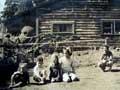
Population
The permanent residents of Great Barrier live with no reticulated water or electricity and are renowned for their self-sufficiency. Holidaymakers flock to the island in summer, lifting the population to 3,000.
Surviving – with lattes
Great Barrier Island has become familiar around the world as the setting for the BBC reality show, Castaway. For three months in 2007 the participants ‘survived’ on the island – but were actually living in Harataonga Bay, not far from a café, golf club and other amenities. A farmer who grazed cattle near the location had to move the animals away, in case their mooing destroyed the effect of primitive isolation.
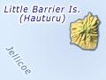
Little Barrier Island (Hauturu)
Bird sanctuary 22 km north-east of Cape Rodney, 90 kilometres north-east of Auckland. Its cone (formed 1–1.5 million years ago) rises steeply out of the sea. The Māori name for the island, Hauturu is also the name of its highest peak (722 m). Signs of long periods of Māori habitation remain in the sacred grove of Pua Mataahu, and low stone walls.
Little Barrier became a reserve in 1894, and is one of the last patches of primordial New Zealand, with 370 different types of plants, as well as tuatara (reptiles), giant wētā (which resemble grasshoppers), and dozens of rare birds.