
Motueka
2013 population: 7,377
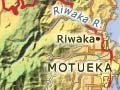
Motueka, or ‘Mot’ as locals call it, lies on the small Motueka Plain near the Motueka River mouth on the western shore of Tasman Bay. It is the third-largest settlement in the Nelson region after Nelson city and Richmond. A further 5,397 people live in the surrounding area. To the west are the Arthur and Pikikiruna ranges, and to the south the Moutere Hills. Motueka is 48 kilometres from Nelson and 57 kilometres from Tākaka.
The exceptional soil fertility and the suitability of the surrounding land for small-farm settlement were the main reasons that the second town of the Nelson settlement was established at Motueka in 1842.
Motueka is primarily a rural service centre. Sheep and cattle are farmed, and hops, fruit (especially apples) and vegetables are grown. Motueka used to be New Zealand’s tobacco-growing centre. However, the crop was no longer profitable after the government removed the requirement for some New Zealand-grown tobacco in locally produced cigarettes in the early 1980s.
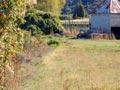
The town has a large seasonal component to its labour force, as orchard workers arrive to pick crops in late summer. Wooden apple crates stacked up at packing sheds are a common sight. Port Motueka is home to the deep-water fishing company Talley’s, and the nearby tidal foreshore features a salt-water swimming pool.
Motueka’s Māori community is centred on Te Āwhina marae.
Riwaka
2013 population: 867
Riwaka is a township 6 km north of Motueka. The Riwaka River valley, like the area around Motueka, is home to many orchards, and most of New Zealand's hops are grown around here. Old hop kilns abound, and red netting stretches over many apple orchards. A road leads up the valley to the Riwaka resurgence, where a branch of the river emerges from a spring at the base of Tākaka hill.
Lower Motueka River valley
The lower valley has many small farming localities such as Pangatōtara, Ngatimoti, Pokororo, Orinoco, Woodstock, Thorpe, Dovedale and Stanley Brook. Two important tributaries, the Pearse and Baton rivers, enter the Motueka River from its western bank. Partly originating from springs, they have water temperatures that are often much colder than the main river in summer.
Wangapeka River valley
The Wangapeka River is one of the main tributaries of the Motueka, draining the western hills. Gold was discovered in the valley in 1861, and Wangapeka (along with Tuapeka in Otago) was immortalised in the ditty ‘Gold, gold, fine bright gold. Tuapeka, Wangapeka, bright red gold.’ 1
The flat lands are farmed, and many of the lower hills are planted in exotic forest. The Sherry River, a tributary of the Wangapeka, was named for the colour of its water. The road end at the head of the valley gives trampers access to the Wangapeka Track and to Mt Owen in Kahurangi National Park.
Golden Downs
The land at the head of the Motueka valley was open country in the 1840s and had probably been burnt off by Māori. A shepherd named Gordon worked there, and the area was originally called Gordon Downs. An accommodation house was built at the Motueka River crossing in 1856. The land was farmed for sheep, but was poor country. From 1926 exotic forests were planted – the beginnings of the Golden Downs State Forest.
Grow your own
Tobacco was grown in the Nelson area from the 1840s. Gold diggers at Tadmor in the 1870s grew their own. They compressed it into plugs by applying a weight to a long pole, which forced the tobacco down into a mould.
Tapawera
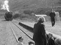
Tapawera was established as a centre when the Midland railway was built in the early 1900s. Small locales such as Kiwi, Tūī and Kākā in the Tadmor valley were also stations on the line. Kiwi was the site of a 1954 protest, where women sat on the lines trying to get the government to keep the line open. Their protests failed.