Arrivals from Polynesia
Māori elders say that when the Polynesian explorers Kupe and later Toitehuatahi reached New Zealand, they landed first in the north, or soon sailed there.
By about 1300 CE, voyaging waka (canoes) had arrived with migrants from Polynesia. Northern descendants trace their lineage to one or more canoes. The main ones that landed at sites around Northland were:
- Kurahaupō – near North Cape
- Ngātokimatawhaorua – Hokianga
- Māmari – Ōmāmari and the Whāngāpē Harbour
- Tinana – Tauroa Point near Ahipara; on a later voyage, renamed Te Māmaru, at Te Ikateretere, near the mouth of the Taipā River
- Māhuhu-ki-te-rangi – various sites
- Mataatua – Hokianga.
Other important canoes included Tākitimu, Riukākara, Waipapa and Ruakaramea, which landed in the far north. Tūnui-ā-rangi, Moekākara and Te Wakatūwhenua are associated with coastal tribes north and south of Whangārei.
Settlements
Some of the migrants moved south, but a number stayed in the warm, fertile north, which had abundant food sources and provided the best chance of survival for tropical plants brought on the canoes.
By the 18th century the north had possibly a quarter of the total Māori population. Archaeological evidence from places such as Pouērua, inland from the Bay of Islands, reveals much about their way of life.
Many settlements were on shores and harbours, and in river valleys. Middens disclose the extent to which Māori enjoyed the abundant fish and seal supplies. Pā (fortified villages) were built for defence, dotting headlands and carved into strategic hill sites and volcanic cones.
Formation of tribes
By the end of the 18th century, the iwi (tribes) of today were taking shape. In the far north, six tribes from the confederation now known as Muriwhenua emerged: Ngāti Kurī, Ngāi Takoto, Te Pātū, Ngāti Kahu, Te Aupōuri and Te Rarawa.
Naming and claiming
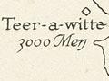
Around 1793 Tukitahua of Ōruru in the far north was kidnapped by Europeans. In captivity he drew a chart of the northernmost part of the region, which was labelled Moodoo Whenua – the first written instance of the collective tribal name Muriwhenua. Northern elders adopted the name when making land claims to the Waitangi Tribunal in the 1980s, but they extended Tuki’s boundaries further south.
Across the central north from Hokianga to the Bay of Islands were Ngāpuhi, a confederation of many tribes, all descended from the ancestor Rāhiri. Each retained a strong independent identity.
To the south of Ngāpuhi on both coasts, there were tribes of the Ngāti Whātua confederation (Te Roroa, Te Uri-o-Hau and Te Taoū) and Ngare Raumati, Ngāi Tāhuhu, Ngātiwai, Te Parawhau, and other tribes around Whangārei.
Tribal changes
From around 1750 to 1840 intermittent intertribal power struggles and battles led to shifts in the balance of power. Fortunes fluctuated, and settlements were often relocated.
In the early 19th century the majority of people in the far north lived in a band of villages from Ahipara to Tokerau (Doubtless Bay). The long northern peninsula was largely deserted. Some tribes had moved offshore to Manawatawhi (Three Kings Islands).
The Ngāpuhi tribe was consolidating its heartland in the fertile area inland of the Bay of Islands. Its influence extended throughout the region – north and east to tribes in the outer Bay of Islands and Whangaruru, northwards into the Ōruru valley and around Mangōnui, and south to related tribes near Whangārei. The population remained much denser in the Bay of Islands and Hokianga than further south. Into this changing scene came Europeans, the first arriving in 1769.