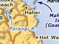
Mercury Bay
Mercury Bay was named by Lieutenant James Cook to mark the place where his expedition observed the transit of the planet Mercury in 1769. Bicentennial celebrations took place in 1969.
A line of islands straddles the entrance to Mercury Bay. Mahurangi Island (Goat Island) off Hahei Beach is the largest (34 ha). The Crown purchased all of them in 1859. A marine reserve was established in this area in 1992.
Whitianga
The principal settlement and only town in Mercury Bay, with a 2013 population of 4,368, an increase of 15.9% since 2006. It is 88 km northeast of Thames via the Kōpū–Hikuai road (State Highway 25A).
Whitianga is short for Whitianga-o-Kupe (Kupe’s crossing place). In Māori tradition Kupe was the explorer who visited Aotearoa before the canoe migrations.
Ngāti Hei, descendants of Hei of the Arawa canoe, are the local tribe, hence the names Te Whanganui-o-Hei (Mercury Bay) and Hahei, the bay further down the coast.
Buffalo Beach, Whitianga’s 3-km sea frontage, is named after HMS Buffalo, a British warship wrecked off the beach in 1840 during a ferocious easterly gale. A cannon from the ship is in the town’s central park.
Timber
The kauri timber industry made early Whitianga. Gordon Browne built a spar station on the east side of the harbour entrance in the 1830s. The stone wharf still exists. Ship-building yards later occupied the site. This was the location of the first town.
The second town developed on the west side after 1880, centred on the timber mill. From around 1887 the Kauri Timber Company expanded the mill, which operated from about 1888 to 1922. At the wharf in front of the mill, triple-masted vessels were loaded for overseas and scows loaded for Auckland. The vast kauri forests were exhausted by the mid-1920s.
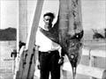
Big fish
A 396-kg mako shark and a 435-kg black marlin swordfish caught off Whitianga in 1925 both broke world records.
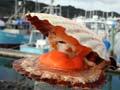
Farming and fishing
Dairy farming on the rich alluvial flats became the district’s economic mainstay. A dairy factory replaced the timber mill on the same site.
Whitianga also became a centre for commercial and deep-sea game fishing. Zane Grey, the famous American writer and game fisher, was a visitor in the 1920s.
Modern boomtown
In the 2000s Mercury Bay was Hauraki–Coromandel’s fastest-growing area. An annual increase in tourism of 3.5% is expected until 2020. Whitianga has extensive flats for expansion.
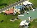
Waterways
Whitianga Waterways, granted resource consent in 2001, is being developed by the Hopper brothers, who also developed Pāuanui. Over a 20-year period it will transform 230 ha of farmland into 5 km of canals and up to 2,500 building sites. Stage 1 was opened in December 2003. The canal development required the building of a bypass road around the existing town.
Cooks Beach
A thriving resort located between Shakespeare Cliff and the mouth of the Pūrangi River. Travellers reach Cooks Beach and its neighbours Hahei and Hot Water Beach either by car ferry from Whitianga or by road from a turnoff at Whenuakite, on State Highway 25. At the eastern end of the beach, on 10 November 1769, James Cook and Charles Green observed the transit of Mercury.
Hahei
A popular beach resort protected by offshore islands. The first marine reserve in the Coromandel was established here in 1992, covering the area north-east of Hahei and Cooks Bluff between Mahurangi and Motukorure islands. Community support for the reserve remains high. Scenic Cathedral Cove can be reached overland or by boat.
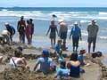
Hot Water Beach
Surf and hot springs under the sand have attracted visitors to this beach for many decades. The springs are places of residual geothermal activity long after volcanic activity stopped in Coromandel about 1.5 million years ago. Here molten rocks deep down in the earth’s crust continue to heat water on its way to the surface. This is how the gold, silver and other minerals of Coromandel were deposited in rocks close to the surface.
Coroglen
Locality 12 km from Whitianga, on State Highway 25. Coroglen was formerly Gumtown, a leading centre for the collection and shipping of kauri gum and the supply of timber camps in the early 1900s. Located on a river that drains into the upper Whitianga Harbour, Gumtown was well placed for water transport. The opening of the hill road to Tapu in 1911 increased its importance as a transport junction, but the opening of the Kōpū–Hikuai road in 1968 diminished it.