Coromandel
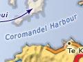
Town 55 km north of Thames on State Highway 25, with a 2013 population of 1,503. The peninsula’s most historic settlement, it occupies the alluvial flats of the Whangarahi Stream, backed by the steep Coromandel Range. Whanganui Island straddles much of the entrance to Coromandel Harbour.
Te Patukirikiri are the tangata whenua (local tribe) of Coromandel. Ngāti Whanaunga and Ngāti Pāoa share that status in the wider area.
Mining
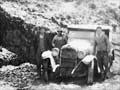
Miners flocked to Coromandel in 1852 and 1862 but, failing to find alluvial gold, soon left. Investment by mining companies from 1868 meant quartz reefs could be mined, so returns improved and the town stabilised. The population was 1,174 in 1874.
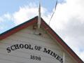
Many fine colonial buildings, like the government buildings (1873), have survived. The Coromandel Goldfield Centre and Stamper Battery and the Coromandel School of Mines and Historical Museum are both located in heritage buildings.
20th century
Gold mining and logging both declined after 1900. Land was farmed and a dairy factory opened in 1911.
The shallow harbour meant the old wharf could only be used at high tide and was expensive to maintain. The decline in coastal shipping and poor roading left farmers isolated.
Coromandel began to grow again in the 1960s, if slowly. Its old-world charm, relative isolation and cheap real estate attracted retired people, artists and ‘alternative lifestylers’. Hannafords Jetty, in deep water at nearby Te Kouma, is now used by tourist ferries.
The closure of Coromandel Hospital in 1994 – as part of government health reforms – was a blow to the town. Built of heart kauri in 1898, it is the town’s finest colonial building. It is now the site of Patukirikiri marae.
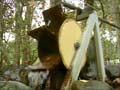
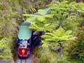
Driving Creek Railway and Potteries, on the road to Kennedy Bay, was developed by potter Barry Brickell, and is open to visitors. The creek takes its name from the driving of kauri logs by the force of water released from dams, down to the harbour for shipping.
Fishing
The fishing fleet peaked at about 25 boats in the early 1980s when Coromandel wharf was landing the second-largest catch of snapper in New Zealand. The introduction of a New Zealand-wide quota system in 1986 restricted total volume according to catch history and also allowed trading of quotas, so many Coromandel fishers either leased or sold their quotas and the Coromandel fish catch was greatly reduced.
Many turned to mussel and oyster farming as sustainable alternatives. Both are sold fresh; larger volumes of mussels are processed at a plant in Tauranga. Oysters are smoked locally.
Tokatea
Mining settlement, now a ghost town, on a 400-metre-high ridge. Tokatea thrived in the early 1870s. It is located near the summit of the Coromandel to Kennedy Bay road. Disused mine shafts and other relics of the mining days are common. A 30-minute track from the road reaches a lookout where marine surveillance took place during the Second World War.
Floating island
Coromandel writer E. H. Audley wrote that ‘on a glorious June morning, with the frost still white and crackling and no slightest stir of wind, [Whanganui] island seemed to float and look warm and tropical.’1
Whanganui Island
Whanganui Island is located at the entrance to Coromandel Harbour, separated from the mainland by a narrow channel. European shipbuilders and traders employed by William Webster settled it in 1836. In the 2000s Whanganui Island was farmed.
Coromandel to Whitianga road
A 22-km route known as the ‘309’ road. On the Coromandel side, Castle Rock, a 521-m castle-like summit, is the core of a remnant volcano, which can be climbed. Three kilometres further on are the Waiau Falls. Nearby is one of the peninsula’s surviving stands of kauri.
Manaia
Manaia, 10 km south of Coromandel town, was gifted by Ngāti Maru to Ngāti Pukenga in recognition of assistance rendered by that Bay of Plenty tribe during the ‘musket wars’. This is one of the few large Māori-owned areas in Hauraki.
Manaia is the largest Māori community on the peninsula north of Thames. The people are of Ngāti Pūkenga, Ngāti Whanaunga and Ngāti Maru tribes. The marae is Te Kou o Rehua.
Manaia was a rich resource area: ‘Ko Manaia, he pataka kai’ (Manaia the food store). Fishing and mussel farming employ locals. Mangrove extension and siltation are problems in Manaia Harbour, as in most other estuarine harbours of the peninsula.
The Manaia Forest Sanctuary, which contains 400 kauri trees, was established in 1972 after local protest against planned logging.