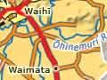


Waihī
Waihī, with a 2013 population of 4,527, is the gold-mining heart of New Zealand. It is situated in the Waihī basin, 136 km from Auckland, 21 km from Paeroa and 83 km from Tauranga. The basin is drained by the Ōhinemuri River and its upper tributaries.
Gold town
Waihī began as a shanty town around a store and a hotel in the 1880s. When the invention of the cyanide process made mining profitable from 1889, the town boomed. Its population reached 5,594 in 1906. Modern Waihī has a wealth of gold-mining heritage buildings.
Electronics
A small radio-manufacturing and repair service opened in Waihī in 1932. A special licence to make radios during the Second World War boosted production. The company went into partnership with Pye in 1949 and was purchased by Philips in 1966.
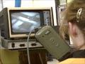
Pioneers of the airwaves
The first television transmission in New Zealand was made at Waihī in 1954.
By 1978 the Waihī factory had made more than 250,000 television receivers and had a workforce of 400. Deregulation spelled hard times for the industry and the factory closed in 1986. Since 1986 Waihī has been home to an electronics manufacturing business set up by an engineer and product developer who had worked at the Philips plant.
A gold town once again
Underground mining finished at the Martha mine in 1952. However, rising gold prices and new, more economic mining methods rekindled interest in gold mining in the 1980s. The Martha mine re-opened in 1987, this time as an open pit mine. By 2010 the pit had reached a depth of 195 metres. The ore and waste rock are transported to a site 2 km away for processing and storage.
Favona underground mine, 2 km from Waihī, opened in 2006. This mine caused only minor disruption to the surface, compared with the massive earth removals involved in open pit mining.
A crushing load
The Victoria stamper battery, built in 1897, had, at maximum production, 200 stamp heads crushing 800 tonnes of ore each day, making it one of the largest in the world. Ore was transported by rail from Waihī. It closed in 1954, two years after mining finished at the Martha mine. The building survives and in 2010 was being restored, and a tramway operated around the site.
Waikino
Locality at the western end of the Waihī basin, Waikino was chosen as a site for the Victoria battery, built to crush ore from the Martha mine, to take advantage of the combined water flow of the Ōhinemuri and Waitekauri rivers. The nearby Ōwharoa Falls can be seen from the road to Waitekauri.
Waitekauri
Locality on the Waitekauri River 5 km north of Waikino. Gold was found at Waitekauri in 1870. The main mine was the Golden Cross at the head of the Waitekauri River, while other mines worked reefs further north toward the Maratoto Stream. By 1914 the known ore reserves were exhausted.
The Golden Cross mine worked once again between 1991 and 1998, producing 20.5 tonnes of gold and 52 tonnes of silver.
Karangahake Gorge
The gulch cut by the Ōhinemuri River through Hauraki’s backbone, with the Coromandel Range on the north side and the Kaimai Range on the south side. Extensive volcanic and geothermal activity ending about 10 million years ago produced gold- and silver-bearing reefs.
Hauraki tribes built numerous pā in the gorge. In 1820 missionary Samuel Marsden became the first European to use the route.
Reefs found at Karangahake in 1882 were initially unprofitable to work. However, that changed with the introduction of the cyanide process in 1889, which greatly increased recovery rates of gold and silver. Karangahake was a world leader in using this technique.
Karangahake township grew on the narrow flat on the north side of the Ōhinemuri, opposite the stamper batteries on the south side. Its population peaked at close to 1,400 in 1911. It all but vanished after mining ended around 1920.
After the closure of the Paeroa–Waihī railway in 1977 enthusiasts promoted a historic walkway through the gorge. The first stage was completed in 1985 and opened on the 85th anniversary of the start of railway construction in 1900. Two further stages followed to make a 7-km walkway.
Waitāwheta
The most important mines in the Karangahake area were on the Waitāwheta River, a southern tributary of the Ōhinemuri. Nearby Karangahake mountain was tunnelled and excavated from close to the summit down to over 100 m below sea level – substantially hollowed out. The Talisman mine was the third most productive gold mine in New Zealand. (The first was Martha and the second Waiuta on the West Coast.)
The Waitāwheta gorge track goes up into the Kaimai Mamaku Forest Park.