Kennedy Bay (Harataunga)
The bay bears the name of John Kennedy, a timber merchant who was robbed and murdered by ex-convicts in 1843.
In 1852 Ngāti Tamaterā of Hauraki gifted land at Harataunga to Ngāti Porou. The main reason was to give the East Coast tribe a stopover place on trading voyages to Auckland. Also, the great ancestor of Ngāti Porou, Paikea, made landfall at Ahuahu (Great Mercury Island) from Hawaiki, and is said to have left descendants at Harataunga. This gift was later recognised by the Native Land Court.
Harataunga is the largest area of Māori land in Hauraki. It continues to provide an economic base for a vital Māori community. The school dates from 1894. A new wharenui (meeting house), carved by the late Pakariki Harrison, opened in 1996.
Whangapoua
A large estuarine harbour 6 km from Kennedy Bay by sea. The road connection via Coromandel town, however, involves two steep climbs across mountains – a stark illustration of the transport difficulties posed by the peninsula’s rugged topography.
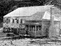
Busy mill!
Built in 1861 at a cost of £15,000, the Whangapoua timber mill was one of the colony’s earliest major industrial plants. It delivered 236–283 cubic metres of sawn timber weekly.
Extraction of Whangapoua kauri led to conflicts known as the ‘Log Wars’ involving rival European timber millers and the Mangakāhia family. It contributed to the passage of the Timber Floating Act 1873, which strengthened the rights of timber millers.
Large-scale plantings of mainly radiata pine after 1950 made the Whangapoua State Forest (7,800 ha) Coromandel’s largest. The destruction of regenerating native forest was an unfortunate cost.
Whangapoua Beach was subdivided in 1961–62.
Kuaotunu
Beach and holiday settlement 20 km north of Whitianga. The discovery of good gold-bearing reefs in 1889 created a boomtown and the eastern peninsula’s most productive goldfield.
By 1915 the gold workings were exhausted and so too was the life of the once bustling town. Many of its buildings were dismantled for use elsewhere.
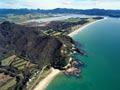
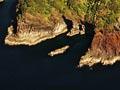
Ōpito Bay
The beach at the end of the Kuaotunu peninsula, reached by the very scenic Black Jack Road.
Ōpito is well known in New Zealand archaeology as the source of Tahanga basalt, a fine-grained stone prized for tool making by Māori throughout the northern North Island. Excavations at the bay in the 1950s yielded valuable information on early human settlement and wildlife at the time, including moa and seals.
In the late 1950s Ōpito became popular with holidaymakers, despite the notoriously narrow and winding Black Jack Road and the lack of services. Local farmers subdivided two small areas, and in the early 2000s a large subdivision north of the existing settlement was proposed.
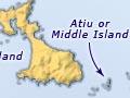
Mercury Islands (Iles d'Haussez)
The Mercury Islands were named by Lieutenant James Cook because of their proximity to the place where he observed the transit of the planet Mercury in 1769. In 1827 they were named Iles d’Haussez by French explorer Dumont d’Urville. The group consists of seven islands within a rectangle 18 km by 10 km. The four larger ones, in order of declining size, are: Great Mercury Island (Ahuahu), Red Mercury Island (Whakau), Kawhitu or Stanley Island, and Double Island (Moturehu). The three smaller ones are Atiu or Middle Island, Green and Korapuki islands.
Ahuahu was occupied by both early Māori and Pākehā. The local tribes are Ngāti Hei and Ngāti Karaua.
The Crown purchased Great Mercury (Ahuahu), Kawhitu or Stanley Island and Double Island (Moturehu) in 1858–65. Great Mercury passed into private ownership soon after. In the late 1970s the Crown entered into negotiations to acquire ownership, but these broke down and the island was sold to new private owners.
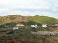
Ahuahu
Ahuahu, in Ngāti Porou tradition, is the landfall of Paikea from Hawaiki, where he covered himself with sand (ahu). The island was large enough (16 sq km) to support a semi-permanent Māori population, as evidenced by numerous pā sites and storage pits. Later, under private ownership, cattle and sheep were farmed. Life for settler families was austere and isolated, the closest neighbours being a boat trip away at Whangapoua or Kuaotunu.
Red Mercury, the outermost of the group, is andesitic and undulating. Count Felix von Luckner sheltered there for a time after escaping from the internment camp for enemy aliens on Motuihe Island in 1917.
In 1964 the Crown set aside Kawhitu and Double Island as wildlife reserves. In 1968 Māori gifted Red Mercury, Green, Middle and Korapuki islands to the Crown as scenic and wildlife reserves. The Hauraki Gulf Maritime Park manages them, and skindiving is popular around them.
Inshore east coast islands
A group of islands lie south of the Mercury Islands and east of Ōpito Bay, the largest being Ōhinau Island (28 ha), the site of a lighthouse since 1924.