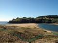
Tairua
An early timber settlement and now a flourishing holiday town, with a population of 1,227 in 2013. Tairua is 41 km east of Thames and 37 km south of Whitianga. Paku hill (179 m), which overlooks the town, was once an island.
In 1843 HMS Tortoise loaded kauri spars from the Tairua coast. In 1864 a timber mill was built on the edge of the harbour. A township grew up but by 1909 the kauri forests were exhausted and the mill closed.
A dairy factory operated from 1922, but was too small to be profitable and closed in 1949. A large subdivision in 1948 heralded Tairua’s future as a holiday resort, which was reinforced when the Kōpū–Hikuai road opened in 1967 and greatly shortened the distance from Auckland and Hamilton.
Shoe and Slipper islands
Two large islands lie off Tairua: Shoe Island (Motuhoa, 40 ha) and Slipper Island (Whakahau, 187 ha). Shoe Island remains in Māori ownership and Slipper Island is privately owned.
Pāuanui
Purpose-built holiday and retirement resort located on the large sandspit fringing the south side of Tairua Harbour, with a permanent population of 750 in 2013. Pāuanui hill (387 m), to the south of the settlement, can be climbed.
In 1967, at the time the Kōpū–Hikuai road opened, developers Ian and Tony Hopper, in collaboration with town planner Tony Easdale, bought land at Pāuanui for a new type of housing and recreational development, with all aspects of the layout devised and designed at the same time, including roads, utilities, housing guidelines, community amenities, canals and boat mooring facilities.
The first stage of the Pāuanui development opened in 1993. The complete levelling of the front dune system was an environmental cost.
Aldermen Islands
A cluster of jagged volcanic islands, islets and rocks 17.5 km east of Tairua. James Cook jokingly named them the ‘Court of Aldermen’, having just named Tūhua to the south Mayor Island. Rising up to 200 metres straight out of the sea, they are among the most spectacular landforms in New Zealand. In 1933 the Crown proclaimed them a wildlife sanctuary. In 1969 Māori gifted them to the Crown, thereby endorsing that purpose.
Hikuai
Settlement 10 km south-west of Tairua, on the rich alluvial flats of the lower Tairua River. The completion of the Kōpū–Hikuai Road (State Highway 25a) in 1967 made Hikuai the gateway to eastern Coromandel.
In the 1860s a small timber mill and a store to supply loggers and kauri-gum diggers were established at the junction of the Tairua River and Hikuai Stream. Development moved to the present site when deepening of the river caused by timber drives enabled vessels to travel further up the river.
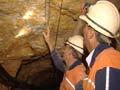
Gold was discovered in the ranges at nearby Neavesville in 1875 but was never profitable. At Broken Hills and Golden Hills highly capitalised mining was more successful in the early 1900s.
Wharekawa
The shores of the Wharekawa Harbour are home to a wide range of wetland and inter-tidal plant communities. The absence of mangroves reflects the high water quality. Ōpoutere beach is the last great undeveloped sand surf beach on the Coromandel. It was home to well-known historian and biographer Michael King.
On the coast between Wharekawa and Whangamatā harbours, Onemana beach settlement is reached via Whitipororua Road, 4 km from State Highway 25.
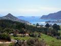
Whangamatā
A beach resort town lying between the Ōtahu River estuary and Whangamatā Harbour, 31 km north of Waihī and 51 km south-east of Thames. It had a 2013 population of 3,471, with a summer peak of about 25,000, many young people being attracted by the beach and surf culture.
The Wentworth valley gave access for kauri timber operations in the upper Tairua catchment. Gum diggers followed the kauri loggers. Gold was discovered in the Wentworth valley in 1887 and on a tributary of the Wharekawa River. Despite poor returns, mining operations continued until around 1910.
A settlement from the 1890s centred on a store and a hotel, visited regularly by steamers and scows. The road from Waihī reached the settlement in 1924.
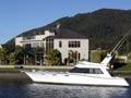
Whangamatā was subdivided in stages: the north end of the beach in the 1930s and 1940s; the south end of the beach, until then Māori land, in the 1950s; Moana Point and Beverly Hills in the 1970s. The building of the causeway to Moana Point in 1976 gave a boost to development. The port area is the commercial centre. A 210-berth marina opened in October 2009 after years of controversy about its environmental impact.
The bar’s wild surf
The bar between Hauturu Island and Whangamatā beach creates optimal conditions for surfers – a left-hand surf break.
The three islands off Whangamatā – Hauturu, Whenuakura and Rawengāiti – became a reserve in 1957 on the decision of their Māori owners.
Whiritoa and Mataora Bay
Whiritoa is a new beach resort located north of Ōtonga Point. A pā site was bulldozed in the course of development.
A short distance to the south lies Mataora Bay, which, like Kennedy Bay, was given to Ngāti Porou by the Hauraki tribes in the mid-19th century. Mataora Bay remains home to a small Māori community.